Approximate Location Map
Large Map »
Latitude: 51.0703 / 51°4'13"N
Longitude: -1.7916 / 1°47'29"W
OS Eastings: 414696
OS Northings: 130131
OS Grid: SU146301
Mapcode National: GBR 517.XHR
Mapcode Global: FRA 7649.1V9
Plus Code: 9C3W36C5+49
Entry Name: Methodist Community Church
Listing Date: 12 October 1972
Grade: II
Source: Historic England
Source ID: 1258943
English Heritage Legacy ID: 445926
ID on this website: 101258943
Location: Salisbury, Wiltshire, SP1
County: Wiltshire
Civil Parish: Salisbury
Built-Up Area: Salisbury
Traditional County: Wiltshire
Lieutenancy Area (Ceremonial County): Wiltshire
Church of England Parish: Salisbury St Thomas and St Edmund
Church of England Diocese: Salisbury
Tagged with: Church building
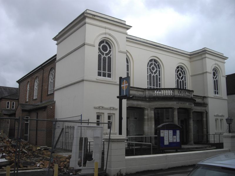
ST EDMUNDS CHURCH STREET
1.
1594 (East Side)
Methodist Community Church
SU 1430 SE 2/554
II GV
2.
1810-11 enlarged and altered 1835. 2 storeys stucco faced 5 bay front, outer
bays projecting. Frieze and moulded cornice, bandbetween storeys on projecting
bays. Italianate fenestration. 5 round headed windows on 1st floor in arched
recesses with marginal glazing, leaded. Moulded string broken up over windows
on outer bays. Ground floors between projecting bays is screened by Doric
colonnade with bowed centre, parapet panelled to side, balustrade over bowed
centre. Ground floor wall has banded rustication. Large panelled double doors
to centre with flanking pilasters. Panelled side doors with flanking pilasters,
plain heavy frieze and cornice over. Ground floors of outer bays have 2 narrow
windows with linked segmental pediments. Entablature returned to sides and
similar round headed windows.
Nos 2 to 10 (even) and Nos 16 to 24 (even) with Methodist Church form a group.
Listing NGR: SU1469630131
External links are from the relevant listing authority and, where applicable, Wikidata. Wikidata IDs may be related buildings as well as this specific building. If you want to add or update a link, you will need to do so by editing the Wikidata entry.


Other nearby listed buildings
