Approximate Location Map
Large Map »
Latitude: 51.2815 / 51°16'53"N
Longitude: 1.0811 / 1°4'51"E
OS Eastings: 614968
OS Northings: 158109
OS Grid: TR149581
Mapcode National: GBR TY2.Q4F
Mapcode Global: VHLGM.P1DX
Plus Code: 9F3373JJ+JC
Entry Name: Highbury Cottages
Listing Date: 7 September 1973
Grade: II
Source: Historic England
Source ID: 1260796
English Heritage Legacy ID: 439483
ID on this website: 101260796
Location: Canterbury, Kent, CT1
County: Kent
District: Canterbury
Electoral Ward/Division: Westgate
Parish: Non Civil Parish
Built-Up Area: Canterbury
Traditional County: Kent
Lieutenancy Area (Ceremonial County): Kent
Tagged with: Cottage
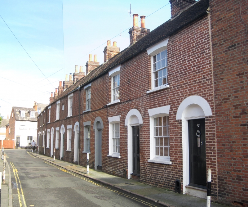
1.
944 KING STREET
(South East Side)
Nos 34 to 42 (consec)
(Highbury Cottages)
TR 1458 SE 2/526
II GV
2.
A terrace dated 1856. 2 storeys red brick. Old tiled roof, 1 cambered sash
each with glazing bars intact. Simple round-headed doorcase, No 35 is now
pebble dashed. Rear elevation has hipped roofs.
Nos 34 to 43 (consec) form a group.
Listing NGR: TR1497758119
External links are from the relevant listing authority and, where applicable, Wikidata. Wikidata IDs may be related buildings as well as this specific building. If you want to add or update a link, you will need to do so by editing the Wikidata entry.


Other nearby listed buildings
