Approximate Location Map
Large Map »
Latitude: 51.0496 / 51°2'58"N
Longitude: -4.0664 / 4°3'59"W
OS Eastings: 255254
OS Northings: 129835
OS Grid: SS552298
Mapcode National: GBR KQ.G3PR
Mapcode Global: FRA 26CB.X6P
Plus Code: 9C3Q2WXM+RC
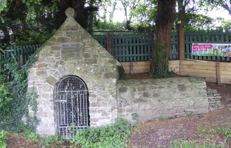
Entry Name: Covered Shelter to Holy Well
Listing Date: 18 March 1987
Grade: II
Source: Historic England
Source ID: 1261612
English Heritage Legacy ID: 437061
ID on this website: 101261612
TAWSTOCK TAWSTOCK
SS 52 NE
4/82 Covered shelter to Holy Well
-
GV II
Covered shelter to Holy Well. Possibly medieval origins, restored 1938. Stone
rubble walls and roof with gable ends. Rounded stone finial to front gable end with
Maltese cross in relief. Small, rectangular on plan. Semi circular headed archway
to front gable end with C20 latticed door. Plaque above. "Holy Well, Tawstock.
Restored 1938. A.B.S.W."
Listing NGR: SS5525429835
External links are from the relevant listing authority and, where applicable, Wikidata. Wikidata IDs may be related buildings as well as this specific building. If you want to add or update a link, you will need to do so by editing the Wikidata entry.


Other nearby listed buildings
