Latitude: 54.6967 / 54°41'48"N
Longitude: -1.1796 / 1°10'46"W
OS Eastings: 452974
OS Northings: 533824
OS Grid: NZ529338
Mapcode National: GBR NG64.F5
Mapcode Global: WHD6F.V6GS
Plus Code: 9C6WMRWC+M5
Entry Name: North East Wing of St Hilda's Hospital
Listing Date: 12 February 1985
Grade: II
Source: Historic England
Source ID: 1263353
English Heritage Legacy ID: 432550
ID on this website: 101263353
Location: Friarage Field, Croft on Heugh, Hartlepool, County Durham, TS24
County: Hartlepool
Civil Parish: Headland
Built-Up Area: Hartlepool
Traditional County: Durham
Lieutenancy Area (Ceremonial County): County Durham
Church of England Parish: Hartlepool St Hilda
Church of England Diocese: Durham
Tagged with: Building
HARTLEPOOL FRIAR STREET NZ 5233 (off east side), Headland 8/69 North-east wing of 12.2.85 St. Hilda's Hospital
- II
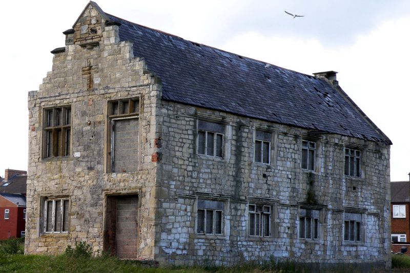
Remains of c.1600 manor house, later used as poor house and latterly as hospital; on site of C13 monastic house. Coursed, hammer-dressed limestone; Welsh slate roof with stone gable coping and reduced end stack to right (north); crow-stepped gable to left (south). 2 storeys; 4 bays to east side, having chamfered openings with mid C20 metal casement windows, now boarded over, and continuous hoodmould. Chamfered window opening altered to doorway at first-floor level in right (north) end. Later extensions to north, south and west, are not of interest. Disused at time of survey.
Listing NGR: NZ5297633824
External links are from the relevant listing authority and, where applicable, Wikidata. Wikidata IDs may be related buildings as well as this specific building. If you want to add or update a link, you will need to do so by editing the Wikidata entry.


Other nearby listed buildings