Approximate Location Map
Large Map »
Latitude: 53.9206 / 53°55'14"N
Longitude: -1.4062 / 1°24'22"W
OS Eastings: 439093
OS Northings: 447326
OS Grid: SE390473
Mapcode National: GBR LRM3.C9
Mapcode Global: WHDB0.CQL8
Plus Code: 9C5WWHCV+6G
Entry Name: Square Outbuilding North of Rear of Bungalow Immediately South of Junction with the Ridge
Listing Date: 22 July 1986
Grade: II
Source: Historic England
Source ID: 1266155
English Heritage Legacy ID: 422840
ID on this website: 101266155
Location: Linton, Leeds, West Yorkshire, LS22
County: Leeds
Civil Parish: Collingham
Built-Up Area: Wetherby
Traditional County: Yorkshire
Lieutenancy Area (Ceremonial County): West Yorkshire
Church of England Parish: Wetherby St James
Church of England Diocese: Leeds
Tagged with: Architectural structure
COLLINGHAM LINTON LANE
SE34NE LS22 (west side)
SE391473
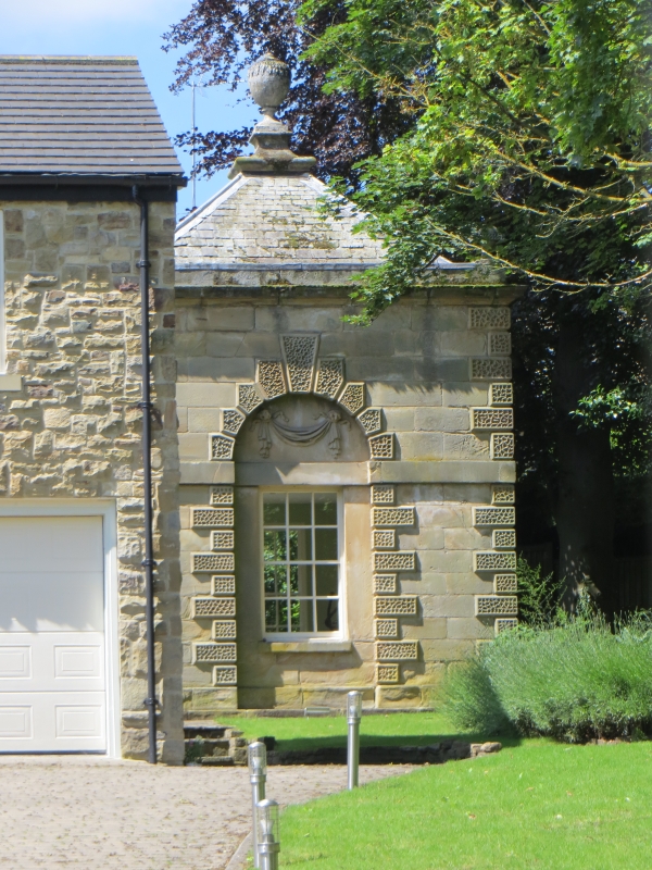
3/44 Square outbuilding
north of rear of
bungalow immediately
south of junction with
The Ridge
II
Building, the original purpose of which is uncertain, now stable and
water-tower. Mid C18, possibly by James Paine.
green-slate roof. Square single cell. Single-storey. 1 x 1 bays. Plinth.
Raised vermiculated rusticated quoins to angles and all openings. Impost band.
Each face has round-arched recess the voussoirs aligned to the courses filled
on 3 sides with a window (blocked) with deep apron and projecting sill, the lintel
being a continuation of the impost band; and doorway on the 4th side with monolithic
jambs and tall double-doors. The tympanum of each arch filled with finely-carved
plaque of differing designs; swags, foliage and to the north a cartouche. Bold
casement-moulded cornice. Blocking course. Corner ball-finials with square band
of vermiculated rustication. Pyramidal roof topped by urn on moulded plinth.
Interior: cobbled floor with drainage channels. In the roof space is large lead
water-tank.
James Paine was the architect of nearby Stockeld Park, 1758-63; this building is on
the southern perimeter of the estate and has similarities to other estate buildings
by Paine.
Listing NGR: SE3909347326
External links are from the relevant listing authority and, where applicable, Wikidata. Wikidata IDs may be related buildings as well as this specific building. If you want to add or update a link, you will need to do so by editing the Wikidata entry.


Other nearby listed buildings
