Approximate Location Map
Large Map »
Latitude: 51.7712 / 51°46'16"N
Longitude: -2.1664 / 2°9'58"W
OS Eastings: 388616
OS Northings: 208074
OS Grid: SO886080
Mapcode National: GBR 1M7.YZF
Mapcode Global: VH94S.DRL1
Plus Code: 9C3VQRCM+FF
Entry Name: Farm Buildings at Snows Farm
Listing Date: 15 February 1994
Grade: II
Source: Historic England
Source ID: 1267032
English Heritage Legacy ID: 419923
ID on this website: 101267032
Location: Stroud, Gloucestershire, GL6
County: Gloucestershire
District: Stroud
Civil Parish: Painswick
Traditional County: Gloucestershire
Lieutenancy Area (Ceremonial County): Gloucestershire
Church of England Parish: Miserden St Andrew
Church of England Diocese: Gloucester
Tagged with: Agricultural structure
PAINSWICK STEANBRIDGE LANE
SO 80 NE
Slad
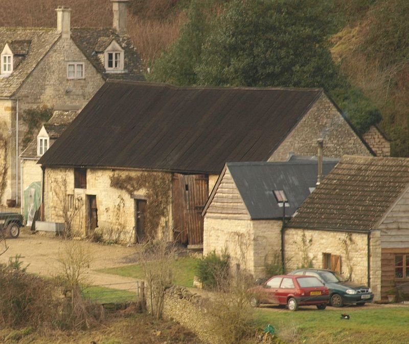
5/10001 Farm building at Snows
Farm
GV II
Group of farm buildings, including barn, open-fronted cart-shed,
and former stable. Early C18 or earlier barn with early/mid C19
additions. Coursed limestone rubble, corrugated iron, stone
slate and concrete tile roofs. A long east-west range extending
opposite the gable end of the wing of the farmhouse (qv), with a
short return to the cart-shed at the right-hand end. The long
central barn with gabled ends is set against the ground slope to
the rear. The front has a square loading-door at eaves level to
the left, above a small double lancet cut from a single stone
and set in plain reveals, and a stable door; towards the
right-hand end is a full-height pair of plank doors, with, to
the left, a smaller plank door to a wood lintol. The barn and
cart-shed have corrugated roofs. To the left, set back, is the
former stable, with reinstated stone slate roof, with a pitching
opening and stable door in the gable facing the farmhouse, and 2
small gabled casement dormers to the front. At the rear, on a
short flight of steps, is a door under a gabled head. At the
opposite end is the cart-shed, a small unit on an L-plan, with 4
short tapered round piers in coursed rubble; the rear and end
walls in rubble. This is attached to a later C19 gabled shed,
built independently, with concrete tiled roof and with doors to
the east. The barn and this last outbuilding have very large
open-textured stones as plinth and foundation.
Interior: the barn has 4
bays of early trusses with 2 purlins and tie-beams, but one with
queen-post strutting, and the rear wall has a blocked opening
opposite the main doors, but half-depth only; this probably had
a pair of loading doors at this upper level. The low cart-shed
of narrow span has 3 and 2 bays of rough trusses with flush
purlins and tie beams. With
the adjacent farmhouse this range forms a good group with both
hisotrical and architectural interest.
Listing NGR: SO8861608074
External links are from the relevant listing authority and, where applicable, Wikidata. Wikidata IDs may be related buildings as well as this specific building. If you want to add or update a link, you will need to do so by editing the Wikidata entry.


Other nearby listed buildings
