Latitude: 51.8094 / 51°48'33"N
Longitude: -1.6349 / 1°38'5"W
OS Eastings: 425264
OS Northings: 212371
OS Grid: SP252123
Mapcode National: GBR 5SW.FGZ
Mapcode Global: VHBZS.MS18
Plus Code: 9C3WR958+Q2
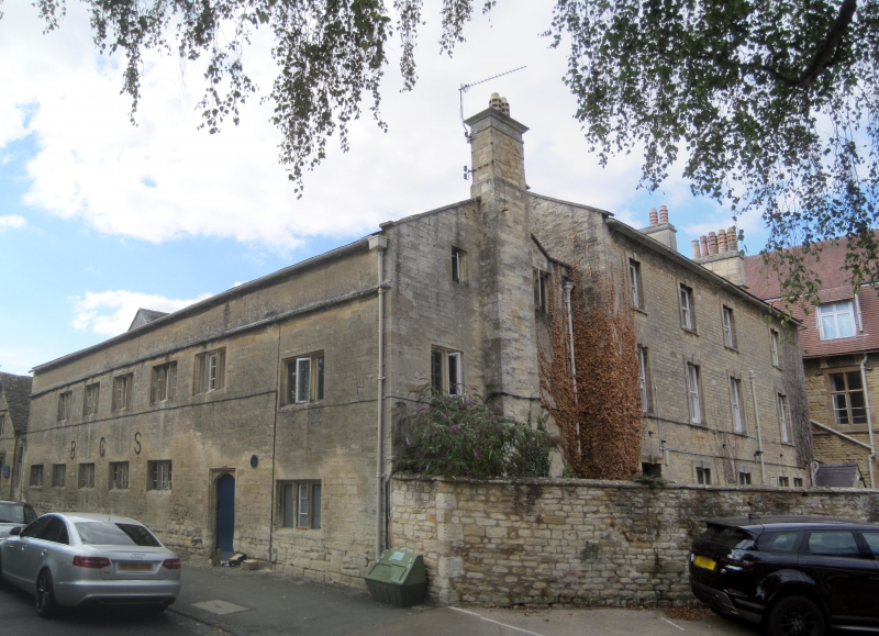
Entry Name: Burford Grammar School (Main Part Including Lenthall House)
Listing Date: 12 September 1955
Grade: II*
Source: Historic England
Source ID: 1267149
English Heritage Legacy ID: 419538
ID on this website: 101267149
Location: Burford, West Oxfordshire, OX18
County: Oxfordshire
District: West Oxfordshire
Civil Parish: Burford
Built-Up Area: Burford
Traditional County: Oxfordshire
Lieutenancy Area (Ceremonial County): Oxfordshire
Church of England Parish: Burford
Church of England Diocese: Oxford
Tagged with: Architectural structure School building
BURFORD AND UPTON CHURCH LANE AND SIGNET (North Side) SP2512 (Enlargement) Burford Grammar School 7/40 (main part including 12.9.55 Lenthall House).
GV II*
Grammar school. Rebuilt c.1570's for Simon Wysdom, altered and extended mid-C19. Coursed and squared rubble, low pitched slate roof, coped verges, ashlar chimney to right. 2 storeys; 1-5-1 bays; rebated hollow chamfered mullion windows of 3 lights, altered ground floor left, lower storey levels to right hand bay, string over 1st floor, 6 courses below eaves. Tudor arch door within relieving arch to left of right hand bay, ogee mouldings, plain spandrels. Tablet inserted over ground floor right- hand window: "All law and praise be to God:/A. R. Reginde. Elizabeth.xxi Symon. Wysdom, Alderman of Burford. Re-edified/. and.buylded.this.howse. A.D'O 1579:" Over the ground floor are 3 tie rods whose ends form the letters B.G.S. Interior: in lobby of door the former decayed nail-studed door is displayed; in ground floor East room a wide Tudor arch fire-place. The East gable return has single-and 2-light mullion windows and central chimney stack; to right is pointed doorway with light Tudor arching and ogee and hollow mouldings like the door to front, label over. The school extends North and East (Lenthall House), the link block is mid C19 the North-east block is 1870s or 1880s, rough-faced rubble, 2 storeys and attic in mansard plain tile roof; cross-mullion windows with relieving arches over, the gable end to East breaks forward below a corbelled-out attic end gable; stepped chimney to North return. The date tablet was moved here from Simon Wysdom's Almshouses (demolished).
Listing NGR: SP2526412371
External links are from the relevant listing authority and, where applicable, Wikidata. Wikidata IDs may be related buildings as well as this specific building. If you want to add or update a link, you will need to do so by editing the Wikidata entry.


Other nearby listed buildings