Approximate Location Map
Large Map »
Latitude: 51.3808 / 51°22'50"N
Longitude: 0.5235 / 0°31'24"E
OS Eastings: 575707
OS Northings: 167664
OS Grid: TQ757676
Mapcode National: GBR PPW.76G
Mapcode Global: VHJLV.1K39
Plus Code: 9F329GJF+89
Entry Name: 8 and 10, New Road
Listing Date: 29 October 1952
Last Amended: 21 November 1996
Grade: II
Source: Historic England
Source ID: 1268207
English Heritage Legacy ID: 462109
ID on this website: 101268207
Location: Chatham, Medway, Kent, ME4
County: Medway
Electoral Ward/Division: Chatham Central
Parish: Non Civil Parish
Built-Up Area: Chatham
Traditional County: Kent
Lieutenancy Area (Ceremonial County): Kent
Church of England Parish: Chatham St Mary and St John
Church of England Diocese: Rochester
Tagged with: Building
CHATHAM
TQ7567NE NEW ROAD
762-1/4/19 (South West side)
29/10/52 Nos.8 AND 10
(Formerly Listed as:
NEW ROAD, Chatham Town
Nos.2-38 (Even))
GV II
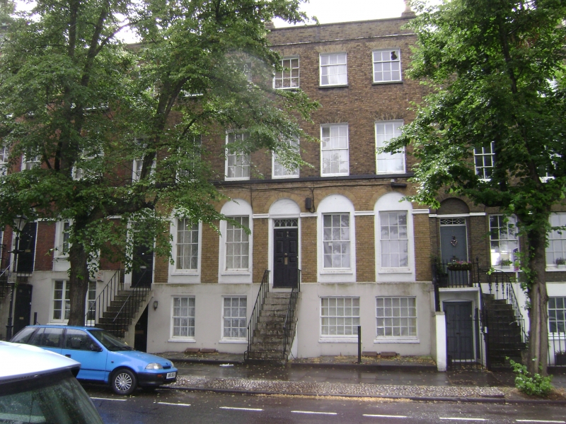
Pair of terraced houses, now offices. c1812. Brick, rendered
basement, weatherboarded rear, brick party wall and ridge
stacks, hipped slate roof.
STYLE: Late Georgian.
PLAN: double-depth plan.
EXTERIOR: 3 storeys and basement; 6-window range. Raised over
a full basement, with a thin cornice and coped parapet;
ground-floor openings in elliptical-arched recesses connected
by channelled impost bands. Steps up to left-hand doorways
with 8-panel doors, narrow overlights with pointed-arched
panes, and 6/6-pane sashes, 3/6-pane second-floor sashes. Wide
10/10-pane basement sashes, and doorways under the stairs.
INTERIOR: No.8 has a central lateral dogleg stair with stick
balusters, curtail and wreathed rail, and a glazed lantern
dome, with round arches dividing the entrance hall. Connected
internally to No.10.
HISTORY: part of a varied terrace (qqv), started in 1794, and
the most advanced in Chatham despite the anachronistic use of
a timber-framed rear elevation.
(The Buildings of England: Newman J: West Kent and the Weald:
London: 1976-: 203).
Listing NGR: TQ7570667665
External links are from the relevant listing authority and, where applicable, Wikidata. Wikidata IDs may be related buildings as well as this specific building. If you want to add or update a link, you will need to do so by editing the Wikidata entry.


Other nearby listed buildings
