Latitude: 51.586 / 51°35'9"N
Longitude: -2.1014 / 2°6'4"W
OS Eastings: 393072
OS Northings: 187470
OS Grid: ST930874
Mapcode National: GBR 2QZ.HK4
Mapcode Global: VH95S.JDFH
Plus Code: 9C3VHVPX+CF
Entry Name: St Marys Hall
Listing Date: 1 July 1976
Grade: II
Source: Historic England
Source ID: 1269256
English Heritage Legacy ID: 460962
ID on this website: 101269256
Location: Malmesbury, Wiltshire, SN16
County: Wiltshire
Civil Parish: Malmesbury
Built-Up Area: Malmesbury
Traditional County: Wiltshire
Lieutenancy Area (Ceremonial County): Wiltshire
Church of England Parish: Malmesbury and Brokenborough
Church of England Diocese: Bristol
Tagged with: Architectural structure
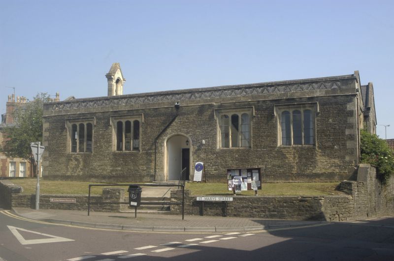
MALMESBURY
ST9387 ST MARY'S STREET
758-1/2/315 (North East side)
01/07/76 St Mary's Hall
GV II
Church, now hall. Rebuilt 1670-80, extended and altered
1830-45. Coursed limestone rubble with slate roof.
PLAN: rectangular rear hall with front range of chambers.
EXTERIOR: single-storey; 4-window range. 2 parallel ranges
with coped gabled ends and quoins, the S range C19 with a thin
cornice and openwork parapet of cusped triangles. 3- and
4-light windows each with elliptical heads and label moulds,
with a central 4-centre arched doorway. 1-window gables except
the left-hand rear which has a relieving arch of a former
window and a mid C19 ashlar gabled bellcote. Reported as
having a gabled porch.
INTERIOR: largely remodelled mid C20. The earliest inscription
dates to c1672.
HISTORICAL NOTE: formerly St Mary's Church, Westport, on the
site of the fine Medieval church destroyed c1643 in the Civil
War by Sir William Waller 'that the enemy might not shelter
themselves against the garrison of Malmesbury.'
(The Buildings of England: Pevsner N: Wiltshire: London:
1963-: 327).
Listing NGR: ST9307287470
External links are from the relevant listing authority and, where applicable, Wikidata. Wikidata IDs may be related buildings as well as this specific building. If you want to add or update a link, you will need to do so by editing the Wikidata entry.


Other nearby listed buildings