Latitude: 51.5832 / 51°34'59"N
Longitude: -2.0981 / 2°5'53"W
OS Eastings: 393299
OS Northings: 187150
OS Grid: ST932871
Mapcode National: GBR 2QZ.QCL
Mapcode Global: VH95S.LG5P
Plus Code: 9C3VHWM2+7Q
Entry Name: 21, High Street
Listing Date: 1 July 1976
Grade: II
Source: Historic England
Source ID: 1269401
English Heritage Legacy ID: 460813
ID on this website: 101269401
Location: Malmesbury, Wiltshire, SN16
County: Wiltshire
Civil Parish: Malmesbury
Built-Up Area: Malmesbury
Traditional County: Wiltshire
Lieutenancy Area (Ceremonial County): Wiltshire
Church of England Parish: Malmesbury and Brokenborough
Church of England Diocese: Bristol
Tagged with: Building
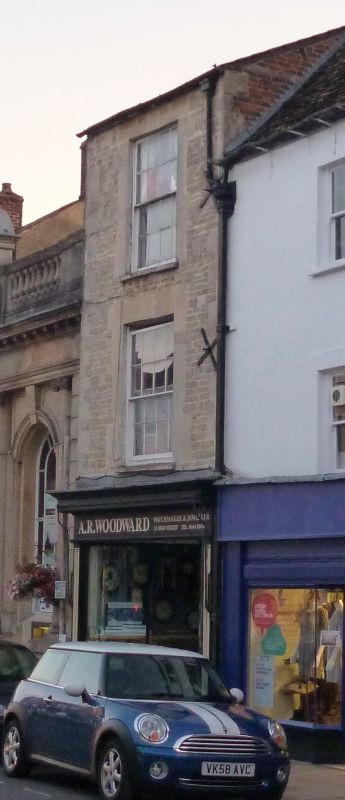
MALMESBURY
ST9387 HIGH STREET
758-1/4/149 (West side)
01/07/76 No.21
GV II
House and shop. Rebuilt mid C19. Coursed, squared limestone
with limestone dressings, brick party wall stack and Welsh
slate roof. Double-depth plan.
3 storeys; 1-window range. C20 shop front, with 8/8-pane
horned sashes above.
INTERIOR: not inspected.
Listing NGR: ST9329187149
External links are from the relevant listing authority and, where applicable, Wikidata. Wikidata IDs may be related buildings as well as this specific building. If you want to add or update a link, you will need to do so by editing the Wikidata entry.


Other nearby listed buildings