Latitude: 51.5833 / 51°34'59"N
Longitude: -2.0977 / 2°5'51"W
OS Eastings: 393323
OS Northings: 187160
OS Grid: ST933871
Mapcode National: GBR 2QZ.QFR
Mapcode Global: VH95S.LGCM
Plus Code: 9C3VHWM2+8W
Entry Name: 16 and 18, High Street
Listing Date: 1 July 1976
Grade: II
Source: Historic England
Source ID: 1269398
English Heritage Legacy ID: 460810
ID on this website: 101269398
Location: Malmesbury, Wiltshire, SN16
County: Wiltshire
Civil Parish: Malmesbury
Built-Up Area: Malmesbury
Traditional County: Wiltshire
Lieutenancy Area (Ceremonial County): Wiltshire
Church of England Parish: Malmesbury and Brokenborough
Church of England Diocese: Bristol
Tagged with: Building
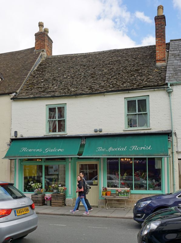
MALMESBURY
ST9387 HIGH STREET
758-1/4/146 (East side)
01/07/76 Nos.16 AND 18
GV II
Inn, now 2 houses and shops. Mid C16, divided c1809, later C19
shop fronts. Limestone rubble, with timber square framing
refronted in brick early C19, brick stack to N of
through-passage below ridge with a stone slate roof to the
left and slate to the right.
PLAN: U-shaped courtyard plan with a single-depth front range
and parallel rear wings flanking through-passage.
EXTERIOR: 2 storeys; 3-window range. No.16 has a good mid C19
shop front with panelled pilasters and consoles to fascia and
cornice, and horned 2/2-pane first-floor sashes, No.18 has a
C20 shop front with plate-glass and a single 2/2-pane sash
with exposed frame, and a central through-passage with exposed
square framing and brick noggingg. N side of rear range has an
attic 3-light ovolo-moulded mullion window; matching rear
gables to the wings.
INTERIOR: details of No.16 include a first-floor front room
with left-hand Tudor-arched stone fire surround and chamfered
beams, a timber stair in two sections with a door and winder
stair to the attic. N wing of 2 storeys and attic has plank
and muntin panelling partitions, chamfered beams with carved
stops, some panelled cupboards, doors and door frames with old
furniture; 3-bay roof with an extended collar truss between
dormers carried at one end by 2 elaborately turned balusters,
possibly from a former galleried courtyard of inn. No.18
altered.
HISTORICAL NOTE: medieval inn on this site in 1540, still open
in 1751, closed by 1809. Shop front of No.16 probably built
for a druggist in occupation c1828-58.
Listing NGR: ST9333187161
External links are from the relevant listing authority and, where applicable, Wikidata. Wikidata IDs may be related buildings as well as this specific building. If you want to add or update a link, you will need to do so by editing the Wikidata entry.


Other nearby listed buildings