Approximate Location Map
Large Map »
Latitude: 50.1503 / 50°9'0"N
Longitude: -5.0632 / 5°3'47"W
OS Eastings: 181261
OS Northings: 32293
OS Grid: SW812322
Mapcode National: GBR ZD.TR5W
Mapcode Global: FRA 088M.C8Q
Plus Code: 9C2P5W2P+4P
Entry Name: Wall South East of Arwenack Manor
Listing Date: 23 January 1973
Grade: II
Source: Historic England
Source ID: 1270062
English Heritage Legacy ID: 460141
ID on this website: 101270062
Location: Falmouth, Cornwall, TR11
County: Cornwall
Civil Parish: Falmouth
Built-Up Area: Falmouth
Traditional County: Cornwall
Lieutenancy Area (Ceremonial County): Cornwall
Church of England Parish: Falmouth King Charles the Martyr
Church of England Diocese: Truro
Tagged with: Wall
FALMOUTH
SW8132SW GROVE PLACE
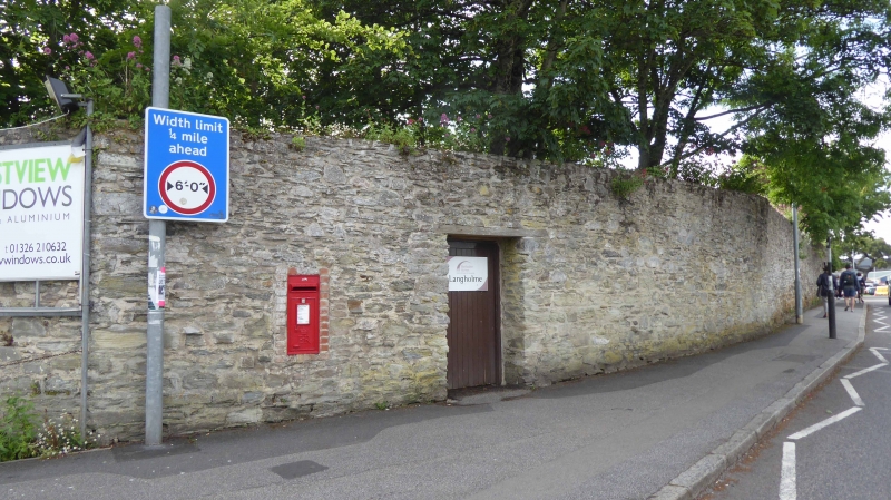
843-1/11/101 Wall, south east of Arwenack Manor
23/01/73
GV II
Garden wall of great house. Possibly C16 in part but much
rebuilt probably in the C18. Killas rubble. High wall with
later doorway to centre of road frontage, letterbox set into
wall left of doorway. To left-hand return is straight joint
and a pointed-arched niche.
Listing NGR: SW8126132293
External links are from the relevant listing authority and, where applicable, Wikidata. Wikidata IDs may be related buildings as well as this specific building. If you want to add or update a link, you will need to do so by editing the Wikidata entry.


Other nearby listed buildings
