Latitude: 52.7095 / 52°42'34"N
Longitude: -2.7564 / 2°45'22"W
OS Eastings: 348994
OS Northings: 312693
OS Grid: SJ489126
Mapcode National: GBR BJ.2836
Mapcode Global: WH8BT.M5N5
Plus Code: 9C4VP65V+QC
Entry Name: The King's Head Public House
Listing Date: 10 January 1953
Last Amended: 17 November 1995
Grade: II*
Source: Historic England
Source ID: 1270680
English Heritage Legacy ID: 457605
ID on this website: 101270680
Location: Shrewsbury, Shropshire, SY1
County: Shropshire
Civil Parish: Shrewsbury
Built-Up Area: Shrewsbury
Traditional County: Shropshire
Lieutenancy Area (Ceremonial County): Shropshire
Church of England Parish: Shrewsbury St Chad
Church of England Diocese: Lichfield
Tagged with: Pub
SHREWSBURY
SJ4812NE MARDOL 653-1/10/426 (North East side) 10/01/53 The King's Head Public House (Formerly Listed as: MARDOL (East side) King's Head Inn)
GV II*
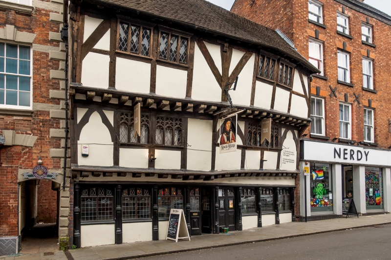
Public house, possibly built as inn. Late C15. Timber-framed with plain tiled roof. 3 storeys, wide 2-window range. Central doorway with continuous band of windows to ground floor, reproducing the traceried detail of original windows. Jettied first storey framed in large panels with cusped arch bracing at each end and centrally forming trefoiled panels. Paired windows forming two 6-light casements with traceried heads. Second storey also jettied, and framed in large panels with plain bracing and joweled central post. Paired windows form 6-light casements with leaded panes. INTERIOR: remains of wall-painting exposed and conserved on internal wall, representing Last Supper. (Smith JT: Shrewsbury: Topography and Domestic Architecture to the Mid C17: 1953-).
Listing NGR: SJ4899412693
External links are from the relevant listing authority and, where applicable, Wikidata. Wikidata IDs may be related buildings as well as this specific building. If you want to add or update a link, you will need to do so by editing the Wikidata entry.


Other nearby listed buildings