Latitude: 53.3672 / 53°22'1"N
Longitude: -1.4747 / 1°28'29"W
OS Eastings: 435049
OS Northings: 385716
OS Grid: SK350857
Mapcode National: GBR 9GQ.BR
Mapcode Global: WHDDP.9MZJ
Plus Code: 9C5W9G8G+V4
Entry Name: Roundabout Hostel and Attached Boundary Wall
Listing Date: 28 June 1973
Grade: II
Source: Historic England
Source ID: 1271021
English Heritage Legacy ID: 456390
ID on this website: 101271021
Location: Highfield, Sheffield, South Yorkshire, S2
County: Sheffield
Electoral Ward/Division: Nether Edge and Sharrow
Parish: Non Civil Parish
Built-Up Area: Sheffield
Traditional County: Yorkshire
Lieutenancy Area (Ceremonial County): South Yorkshire
Church of England Parish: Sheffield St Mary, Bramall Lane
Church of England Diocese: Sheffield
Tagged with: Building
SHEFFIELD
SK38NE ST BARNABAS ROAD
784-1/6/675 (North side)
28/06/73 Nos.11-17 (Odd)
Roundabout Hostel and attached
boundary wall
II
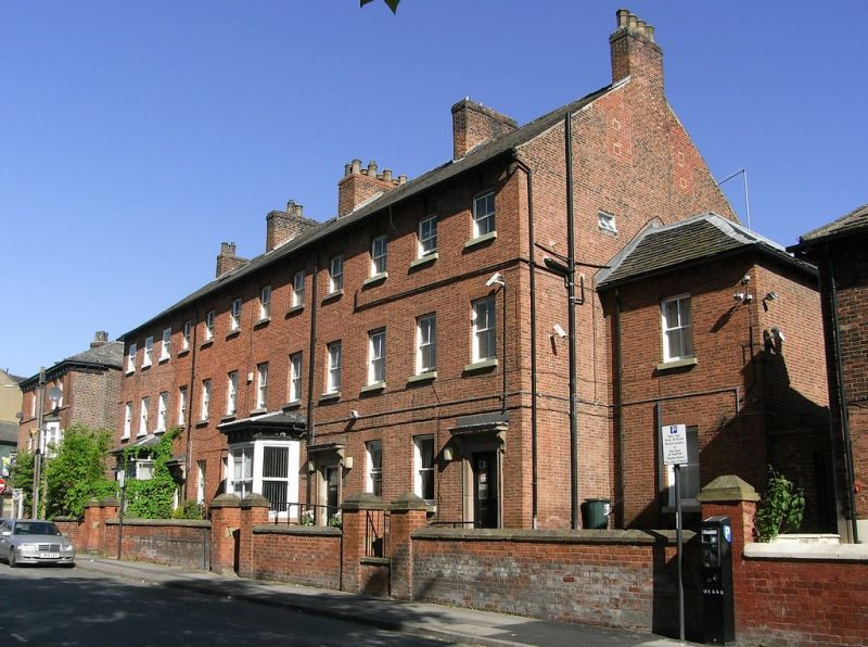
4 houses, now hostel, and attached boundary wall. Late C18,
with late C19 and late C20 alterations. Brick with stone
dressings and gabled and hipped slate and stone slate roofs
with 3 ridge and 2 gable stacks.
3 storeys plus garrets; 12 window range. Windows are plain
sashes. Above, 12 smaller plain sashes. Ground floor has to
left a canted hipped bay window flanked by single doors. To
right, a similar bay window flanked to left by 2 windows and
to right by a door. To right again, 2 windows and beyond them,
a door. All the doors have moulded stone surrounds with flat
hoods on curved brackets. Left return has a hipped 2 storey
addition with a single window and below, a square wooden
3-light bay window. Right return has a similar addition with a
window on each floor, and stone slate roof. Each gable has 2
garret windows. INTERIOR not inspected.
Outside, attached brick boundary wall with gabled stone coping
and 10 square gate piers with chamfered square caps.
Listing NGR: SK3504985716
External links are from the relevant listing authority and, where applicable, Wikidata. Wikidata IDs may be related buildings as well as this specific building. If you want to add or update a link, you will need to do so by editing the Wikidata entry.


Other nearby listed buildings