Latitude: 51.8681 / 51°52'5"N
Longitude: -2.2462 / 2°14'46"W
OS Eastings: 383147
OS Northings: 218866
OS Grid: SO831188
Mapcode National: GBR 1KZ.WF8
Mapcode Global: VH94C.09XR
Plus Code: 9C3VVQ93+6G
Entry Name: Remains of Monastic Infirmary
Listing Date: 23 January 1952
Last Amended: 15 December 1998
Grade: I
Source: Historic England
Source ID: 1271583
English Heritage Legacy ID: 472141
Also known as: Infirmary Arcade
ID on this website: 101271583
Location: Gloucester, Gloucestershire, GL1
County: Gloucestershire
District: Gloucester
Electoral Ward/Division: Westgate
Parish: Non Civil Parish
Built-Up Area: Gloucester
Traditional County: Gloucestershire
Lieutenancy Area (Ceremonial County): Gloucestershire
Church of England Parish: Hempsted with Gloucester, Saint Mary de Lode and Saint Mary de Crypt
Church of England Diocese: Gloucester
Tagged with: Arcade Architectural structure
GLOUCESTER
SO8318NW CATHEDRAL PRECINCTS 844-1/8/58 Remains of Monastic Infirmary 23/01/52 (Formerly Listed as: CATHEDRAL PRECINCTS Remains of Abbey wall, Abbot's Palace; Little Cloisters & Monastic remains on N)
GV I
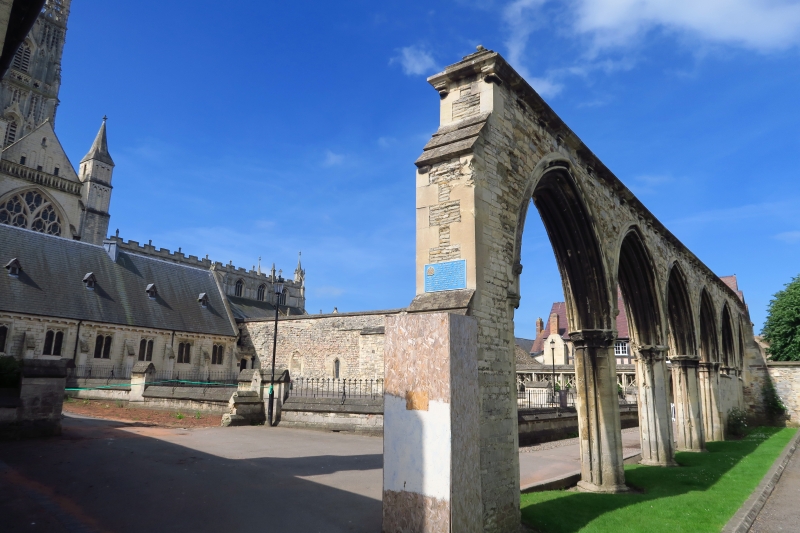
Remains of the former Infirmary of the Benedictine Abbey of St Peter. Early C13. In C17 the east end of the infirmary, formerly St Bridget's Chapel, demolished, and the west end incorporated in a cluster of tenements called Babylon; in 1860 the tenements removed and the surviving C13 masonry exposed and consolidated. Ashlar and rubble. The remains of the aisled infimary hall comprise the lower part of the wall at the west end, six western bays of the south arcade, and two western piers of the former north arcade. EXTERIOR: in the west wall the entrance doorway with moulded arch with hoodmould; the piers to both arcades have attached shafts with fillets, the capitals either moulded or carved with stiff-leaf; the arches of the south arcade elaborately moulded and framed by hoodmoulds with carved stops; above the south arcade the wall is topped by a C19 weathered capping with overhangs supported on corbels. Scheduled Ancient Monument. (BOE: Verey D: Gloucestershire: The Vale and the Forest of Dean: London: 1976-: 222).
Listing NGR: SO8314718868
External links are from the relevant listing authority and, where applicable, Wikidata. Wikidata IDs may be related buildings as well as this specific building. If you want to add or update a link, you will need to do so by editing the Wikidata entry.


Other nearby listed buildings