Latitude: 52.6034 / 52°36'12"N
Longitude: 1.7347 / 1°44'4"E
OS Eastings: 652985
OS Northings: 307172
OS Grid: TG529071
Mapcode National: GBR YQZ.MF4
Mapcode Global: WHNVZ.MT8K
Plus Code: 9F43JP3M+8V
Entry Name: Church of St John
Listing Date: 9 December 1976
Grade: II
Source: Historic England
Source ID: 1271806
English Heritage Legacy ID: 468659
Also known as: Saint John’s Church, Great Yarmouth
ID on this website: 101271806
Location: St John's Church, Great Yarmouth, Norfolk, NR30
County: Norfolk
District: Great Yarmouth
Electoral Ward/Division: Nelson
Parish: Non Civil Parish
Built-Up Area: Great Yarmouth
Traditional County: Norfolk
Lieutenancy Area (Ceremonial County): Norfolk
Church of England Parish: Great Yarmouth
Church of England Diocese: Norwich
Tagged with: Church building
GREAT YARMOUTH
TG5207SE YORK ROAD 839-1/16/200 (South side) 09/12/76 Church of St John
II
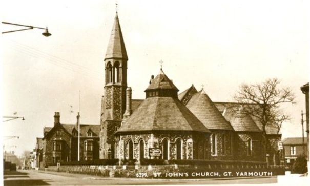
Church. 1857. By JH Hakewill, with later alterations. Flint with red brick and ashlar dressings. Slate roofs. Comprising a nave, apsed chancel and south porch. 1859 south aisle added by AW Morant, nave extended west 1866, north aisle, transept and north chancel aisle 1878, south transept and vestry 1884 by Bottle & Olley. Restored 1989. EXTERIOR: 3 gables to west end, pierced by triple paired lancets to nave, double paired lancets to north aisle, a single paired lancet to south aisle. Paired lancets to north and south aisle flanks. 2 paired lancets to the transept facades under a foiled plate-tracery circle. South transept with a polygonal turret terminating in an open lantern under a pyramid roof, relocated in 1884. Apsed east end, the walls again with lancets. Set to the east but linked by a covered passage is the vestry: hexagonal, 2 lancets to each facet, pyramid roof with lantern. INTERIOR: hexagonal vestry with a boarded ceiling. Nave with 6-bay arcade of circular columns on waterholding bases. On north there are sea-weed capitals, on the south stiff-leaf capitals. Low pointed arches with red brick banding. Scissor-braced nave and aisle roofs, boarded to north aisle. Roll-moulded chancel and sanctuary arches. Sanctuary has clustered colonnettes to the lancet windows. Plain octagonal font on clustered keeled columns.
Listing NGR: TG5298507172
External links are from the relevant listing authority and, where applicable, Wikidata. Wikidata IDs may be related buildings as well as this specific building. If you want to add or update a link, you will need to do so by editing the Wikidata entry.


Other nearby listed buildings