Approximate Location Map
Large Map »
Latitude: 51.366 / 51°21'57"N
Longitude: 1.4205 / 1°25'13"E
OS Eastings: 638193
OS Northings: 168549
OS Grid: TR381685
Mapcode National: GBR X06.CY3
Mapcode Global: VHMCP.KXTP
Plus Code: 9F339C8C+C5
Entry Name: 26, Church Street
Listing Date: 22 April 1975
Grade: II
Source: Historic England
Source ID: 1272409
English Heritage Legacy ID: 449374
ID on this website: 101272409
Location: St Peter's, Thanet, Kent, CT10
County: Kent
District: Thanet
Civil Parish: Broadstairs and St. Peters
Built-Up Area: Broadstairs
Traditional County: Kent
Lieutenancy Area (Ceremonial County): Kent
Tagged with: Building
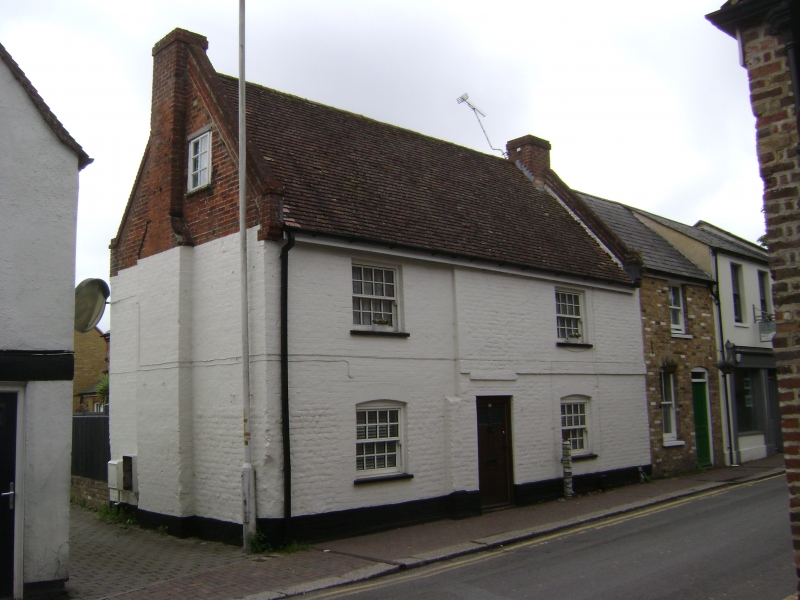
CHURCH STREET
1.
5283
St Peters
No 26
Tr 3868 NW 4/74
II GV
2.
C18. 2 storeys painted brick. Old tiled roof. Gable end with kneelers. 1 sash
and 1 sliding casement on 1st floor. Ground floor windows have cambered heads.
Central doorcase with wooden weather porch on brackets and flush panelled door,
the top 2 panels cut away and glazed.
Listing NGR: TR3819368549
External links are from the relevant listing authority and, where applicable, Wikidata. Wikidata IDs may be related buildings as well as this specific building. If you want to add or update a link, you will need to do so by editing the Wikidata entry.


Other nearby listed buildings
