Approximate Location Map
Large Map »
Latitude: 51.1422 / 51°8'32"N
Longitude: 0.1795 / 0°10'46"E
OS Eastings: 552556
OS Northings: 140365
OS Grid: TQ525403
Mapcode National: GBR MPN.B66
Mapcode Global: VHHQC.2K77
Plus Code: 9F3245RH+VQ
Entry Name: Wall to East of Churchyard of St Peter
Listing Date: 16 January 1975
Grade: II
Source: Historic England
Source ID: 1273070
English Heritage Legacy ID: 446462
ID on this website: 101273070
Location: Fordcombe, Sevenoaks, Kent, TN3
County: Kent
District: Sevenoaks
Civil Parish: Penshurst
Built-Up Area: Fordcombe
Traditional County: Kent
Lieutenancy Area (Ceremonial County): Kent
Church of England Parish: Fordcombe St Peter
Church of England Diocese: Rochester
Tagged with: Wall
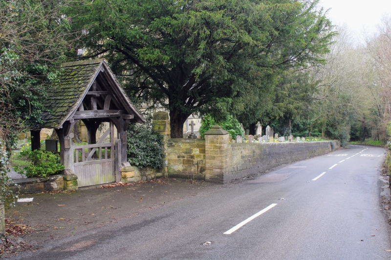
1.
5280 PENSHURST FORDCOMBE
Wall to East of
Churchyard of St Peter
TQ 5240 24/888
II
2.
Coursed freestone wall with late C19 lych gate.
Listing NGR: TQ5255640365
External links are from the relevant listing authority and, where applicable, Wikidata. Wikidata IDs may be related buildings as well as this specific building. If you want to add or update a link, you will need to do so by editing the Wikidata entry.


Other nearby listed buildings
