Latitude: 52.6225 / 52°37'21"N
Longitude: -2.351 / 2°21'3"W
OS Eastings: 376336
OS Northings: 302806
OS Grid: SJ763028
Mapcode National: GBR 07F.DG6
Mapcode Global: WH9DJ.VBNW
Plus Code: 9C4VJJFX+2J
Entry Name: Ryton House Farmhouse
Listing Date: 26 September 1984
Grade: II
Source: Historic England
Source ID: 1273612
English Heritage Legacy ID: 417340
ID on this website: 101273612
Location: Ryton, Shropshire, TF11
County: Shropshire
Civil Parish: Ryton
Traditional County: Shropshire
Lieutenancy Area (Ceremonial County): Shropshire
Church of England Parish: Ryton St Andrew
Church of England Diocese: Lichfield
Tagged with: Farmhouse
SJ 70 SE RYTON C.P RYTON
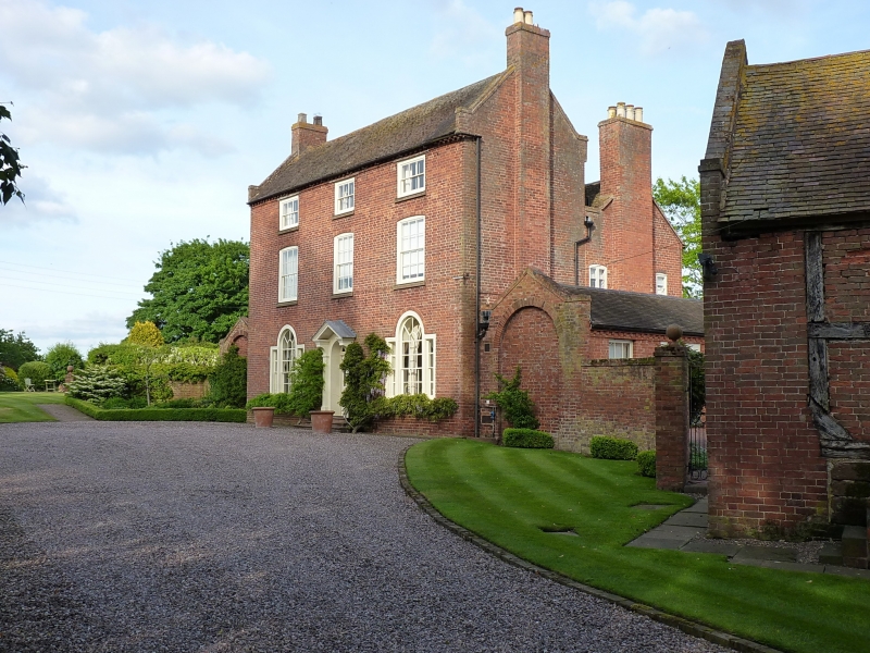
5/128 Ryton House Farm-
house
-
- II
House. Mid C18 with later additions and alterations. Red brick, plain tiled roof.
3 storeys; 3 bays; glazing bar sash windows, reduced proportions to top floor,
Venetian to ground; central recessed entrance with simple fanlight; dentilled brick
eaves cornice, raised verges on kneelers and 2 slightly projecting end stacks.
C19 addition to rear.
Listing NGR: SJ7633602806
External links are from the relevant listing authority and, where applicable, Wikidata. Wikidata IDs may be related buildings as well as this specific building. If you want to add or update a link, you will need to do so by editing the Wikidata entry.


Other nearby listed buildings