Approximate Location Map
Large Map »
Latitude: 52.9516 / 52°57'5"N
Longitude: 0.7408 / 0°44'26"E
OS Eastings: 584221
OS Northings: 342873
OS Grid: TF842428
Mapcode National: GBR R5N.VH5
Mapcode Global: WHKPK.B2ZK
Plus Code: 9F42XP2R+J8
Entry Name: Wayside Cross
Listing Date: 5 June 1953
Last Amended: 1 March 1985
Grade: II
Source: Historic England
Source ID: 1273795
English Heritage Legacy ID: 417103
ID on this website: 101273795
Location: Burnham Overy Town, King's Lynn and West Norfolk, Norfolk, PE31
County: Norfolk
District: King's Lynn and West Norfolk
Civil Parish: Burnham Overy
Traditional County: Norfolk
Lieutenancy Area (Ceremonial County): Norfolk
Church of England Parish: Burnham Overy St Clement
Church of England Diocese: Norwich
TF 83 SW
6/85
BURNHAM OVERY
VELDINGS CORNER
Burnham Overy Town
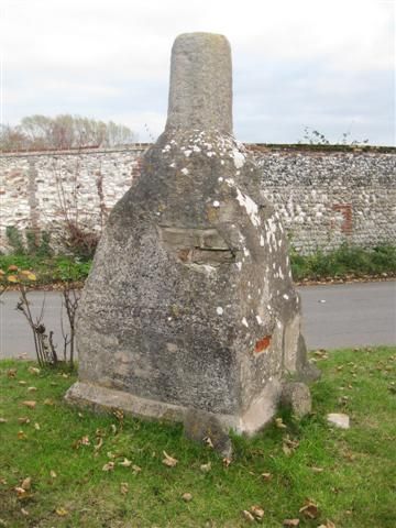
Wayside Cross
(formerly listed as Village Cross)
5.6.53
G.V.
II
Wayside cross, base and shaft partly surviving. Medieval. Stone. Partly rendered brick plinth, square base with telescoping knobs and chamfers to octagonal shaft.
Supposedly gave its name to Brothercross Hundred.
Listing NGR: TF8422142873
External links are from the relevant listing authority and, where applicable, Wikidata. Wikidata IDs may be related buildings as well as this specific building. If you want to add or update a link, you will need to do so by editing the Wikidata entry.


Other nearby listed buildings
