Approximate Location Map
Large Map »
Latitude: 52.0869 / 52°5'12"N
Longitude: -0.3398 / 0°20'23"W
OS Eastings: 513851
OS Northings: 244472
OS Grid: TL138444
Mapcode National: GBR H47.4X4
Mapcode Global: VHGMZ.2T71
Plus Code: 9C4X3MP6+Q3
Entry Name: Granary South West of Numbers 1 and 2
Listing Date: 6 March 1985
Grade: II
Source: Historic England
Source ID: 1274770
English Heritage Legacy ID: 414276
ID on this website: 101274770
Location: Old Warden, Central Bedfordshire, SG18
County: Central Bedfordshire
Civil Parish: Old Warden
Traditional County: Bedfordshire
Lieutenancy Area (Ceremonial County): Bedfordshire
Church of England Parish: Old Warden
Church of England Diocese: St.Albans
Tagged with: Granary
TL 1244 OLD WARDEN CHURCH END
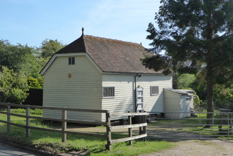
10/131 Granary SW of nos 1 and 2
GV II
Former granary, now commercial store. Later C19, formerly belonging to
Shuttleworth Estate. Timber framed and weatherboarded building raised on
staddle stones. Half-hipped clay tile roof with terracotta ridge cresting and
finial. Triple cube plan of one storey and attics. Plank doors to N, S and W
elevations, loft doors to N and W, with variety of windows inserted in all
elevations.
Listing NGR: TL1385144472
External links are from the relevant listing authority and, where applicable, Wikidata. Wikidata IDs may be related buildings as well as this specific building. If you want to add or update a link, you will need to do so by editing the Wikidata entry.


Other nearby listed buildings
