Approximate Location Map
Large Map »
Latitude: 51.4983 / 51°29'53"N
Longitude: -0.1502 / 0°9'0"W
OS Eastings: 528498
OS Northings: 179325
OS Grid: TQ284793
Mapcode National: GBR BK.F2
Mapcode Global: VHGQZ.BLYS
Plus Code: 9C3XFRXX+8W
Entry Name: 3-11, Upper Belgrave Street SW1
Listing Date: 24 February 1958
Grade: II*
Source: Historic England
Source ID: 1275140
English Heritage Legacy ID: 207300
ID on this website: 101275140
Location: Belgravia, Westminster, London, SW1X
County: London
District: City of Westminster
Electoral Ward/Division: Knightsbridge and Belgravia
Parish: Non Civil Parish
Built-Up Area: City of Westminster
Traditional County: Middlesex
Lieutenancy Area (Ceremonial County): Greater London
Church of England Parish: St Peter Eaton Square
Church of England Diocese: London
Tagged with: Building
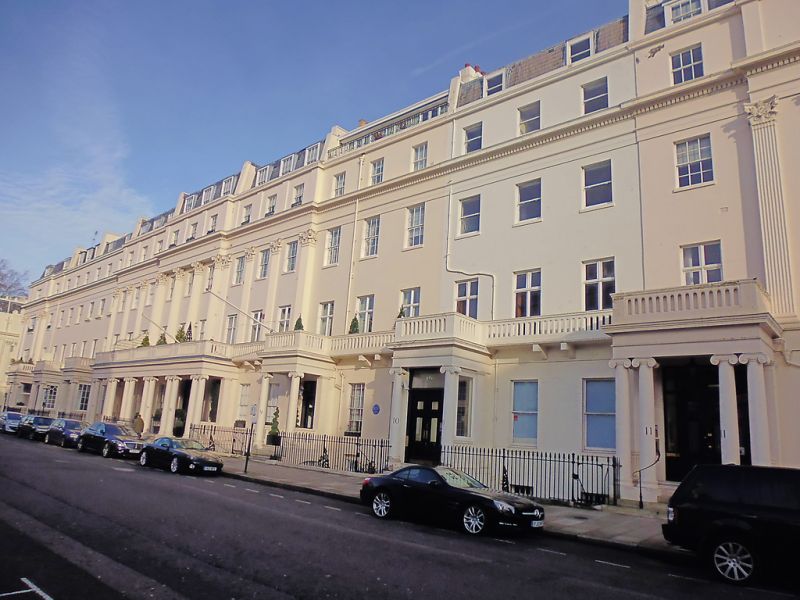
TQ 2879 SW CITY OF WESTMINSTER UPPER BELGRAVE STREET,SW1
97/35 98/4 (north side)
24.2.58 Nos 3 to 11 (consec)
GV II*
Grand terrace of houses. Early to mid C19. Stucco. Low slate mansards. 3
storeys, attic mansard, attic and basement. Graeco-Roman style. Each house 3
windows wide, except end houses, of 2 wide bays each. Centre 3 houses and end
houses with giant Corinthian order rising through first and second storeys.
Centre house and end bays of end houses set forward slightly; Projecting Ionic
porches; centre house with Ionic colonnade across whole width of ground floor.
Various panelled doors. Square headed sashed windows; French casements to first
floor. Some glazing bars. Dentil cornice above second floor, subsidiary cornice
to attic. Spearhead area railings. Pilastered returns. Key position, closing
vista from south-west along Eaton Place.
Listing NGR: TQ2849879325
External links are from the relevant listing authority and, where applicable, Wikidata. Wikidata IDs may be related buildings as well as this specific building. If you want to add or update a link, you will need to do so by editing the Wikidata entry.


Other nearby listed buildings
