Latitude: 53.076 / 53°4'33"N
Longitude: -0.8105 / 0°48'37"W
OS Eastings: 479783
OS Northings: 353857
OS Grid: SK797538
Mapcode National: GBR CLM.5X9
Mapcode Global: WHFHH.JY87
Plus Code: 9C5X35GQ+9Q
Entry Name: 29 and 31 Stodman Street
Listing Date: 19 May 1971
Last Amended: 18 June 2024
Grade: II
Source: Historic England
Source ID: 1277334
English Heritage Legacy ID: 385195
ID on this website: 101277334
Location: Newark-on-Trent, Newark and Sherwood, Nottinghamshire, NG24
County: Nottinghamshire
District: Newark and Sherwood
Civil Parish: Newark
Built-Up Area: Newark-on-Trent
Traditional County: Nottinghamshire
Lieutenancy Area (Ceremonial County): Nottinghamshire
Church of England Parish: Newark-upon-Trent with Coddington
Church of England Diocese: Southwell and Nottingham
Tagged with: Building
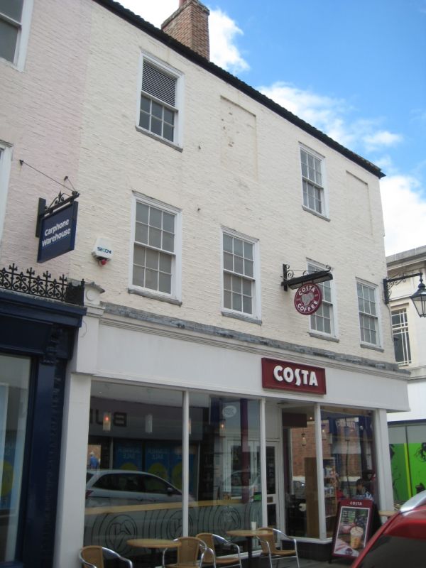
Two late-C18 houses; one with a late-C19 shopfront, the other a late-C20 shopfront.
Two late-C18 houses; one with a late-C19 shopfront, the other a late-C20 shopfront.
MATERIALS: brick walls with timber windows under a clay pantile roof.
PLAN: double pile depth, with a rectangular block with its narrow ends to east and west and front to Stodman Street in the north, with a narrower block of the same width adjoining to the south. The building adjoins neighbouring properties to the east and south.
EXTERIOR: the building is of three-storeys under a double-pitched, ‘M’ profile roof with hips to east and west. Each roof has two chimney stacks rising through its ridge close to the hips. Windows to number 29 are all two-over-two sashes, and number 31’s windows are generally six-over-six sashes.
The north facing façade to Stodman Street is of painted brick in Flemish bond. It is in six bays defined by the openings to its first and second floors; two bays to number 29 to the east, and four to number 31 to the west. On the ground floor, the C19 shopfront to number 29 has plain pilasters and enriched scroll brackets to its cornice and a cast iron crest above. It has plate glass windows with brass mullions which flank a central, recessed glazed door with overlight. To the west, the shopfront of number 31 is thought to date to the late 1980s. It has a plain fascia and deeply recessed off-centre, glazed double-doors flanked by a two-pane window to left and a single pane window to right. At first-floor level, each of the six bays has a window. On the second floor number 29’s two bays each has a window, but two of the four openings to number 31 are blocked. The window openings all have flat-arch brick lintels.
The west elevation faces St Mark’s Place and is brick in three bays, two of which are to the section under the northern of the two blocks of the double pile building. These two northern bays are painted, the rear southernmost bay is exposed brick. There is a dentil course at eaves level not present on the façade. The northern bay has the side return of the C20 shopfront at ground floor level and is solid above that. The rest of the ground floor is solid but there are blocked doorways under segmental brick arches in the central and southern bays. The central and southern bays both have a window at first and second floor, with the second floor window of the second bay being a three-over-six sash. Windows to this elevation are under segmental arch brick lintels. This elevation has pattress plates between first and second floor and a sign reading 'St Mark’s Lane, leading to St Mark’s Place' at ground floor level in the central bay.
Newark appears as Newerche in the 1086 Domesday Book. It’s original name Niweweorche (meaning 'New work') is likely associated with the meaning "New fort". The site of Newark Castle was founded by Robert Bloet, Bishop of Lincoln in 1073 and rebuilt in stone from 1123-1133. A bridge over the Trent was built under charter from Henry I at a similar time. In the C15 and C16, Newark became a prosperous market town centred on the wool and cloth trade and characterised by a dense street pattern surrounding the market square. It was incorporated by the Crown in 1549. Significant development occurred during the C18 in response to growing trade along the Great North Road and the town has a number of terraced buildings from this time. In 1775 a new bridge over the River Trent was constructed, it was further improved in 1848 and forms the current ‘Trent Bridge’. The Market Place was rebuilt in the C18 with coaching inns, the houses of leading citizens and the new Town Hall of 1773 (Grade I) by John Carr of York (1723-1807). By 1801 Newark had a population of 6,730 and was Nottinghamshire’s second town.
It is thought that 29 and 31 Stodman Street were built as two houses in the late C18, with alterations made during the C19 and C20 when shopfronts were added.
External links are from the relevant listing authority and, where applicable, Wikidata. Wikidata IDs may be related buildings as well as this specific building. If you want to add or update a link, you will need to do so by editing the Wikidata entry.


Other nearby listed buildings