Latitude: 51.7553 / 51°45'19"N
Longitude: -1.2566 / 1°15'23"W
OS Eastings: 451410
OS Northings: 206550
OS Grid: SP514065
Mapcode National: GBR 8YY.T9S
Mapcode Global: VHCXV.54KQ
Plus Code: 9C3WQP4V+49
Entry Name: Trinity College, Presidents Lodging
Listing Date: 29 January 1968
Grade: II
Source: Historic England
Source ID: 1278360
English Heritage Legacy ID: 405934
ID on this website: 101278360
Location: Oxford, Oxfordshire, OX1
County: Oxfordshire
District: Oxford
Town: Oxford
Electoral Ward/Division: Carfax
Parish: Non Civil Parish
Built-Up Area: Oxford
Traditional County: Oxfordshire
Lieutenancy Area (Ceremonial County): Oxfordshire
Church of England Parish: Oxford St Mary Magdalen
Church of England Diocese: Oxford
Tagged with: Architectural structure
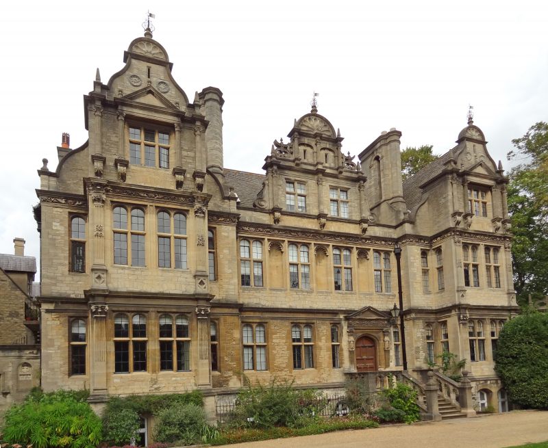
TRINITY COLLEGE
1.
1485
Front Quadrangle
President's Lodging
SP 5106 NW 5/139C 29.1.68.
II
2.
East of chapel, President's Lodging, 1885-7, by Sir Thomas Jackson in Bladon
with Doulton stone dressings. Altered 1970.
Listing NGR: SP5141006550
External links are from the relevant listing authority and, where applicable, Wikidata. Wikidata IDs may be related buildings as well as this specific building. If you want to add or update a link, you will need to do so by editing the Wikidata entry.


Other nearby listed buildings