Approximate Location Map
Large Map »
Latitude: 54.7326 / 54°43'57"N
Longitude: -2.0244 / 2°1'27"W
OS Eastings: 398523
OS Northings: 537512
OS Grid: NY985375
Mapcode National: GBR GF9Q.H8
Mapcode Global: WHB3K.W95R
Plus Code: 9C6VPXMG+26
Entry Name: Shield Ash Farmhouse
Listing Date: 31 January 1967
Grade: II
Source: Historic England
Source ID: 1278790
English Heritage Legacy ID: 404898
ID on this website: 101278790
Location: County Durham, DL13
County: County Durham
Civil Parish: Stanhope
Traditional County: Durham
Lieutenancy Area (Ceremonial County): County Durham
Church of England Parish: Stanhope and Rookhope
Church of England Diocese: Durham
Tagged with: Farmhouse
NY 93 NE
NY 985375
20/137
31/1/67
STANHOPE
B6278
(West side, off)
Shield Ash
Farmhouse
II
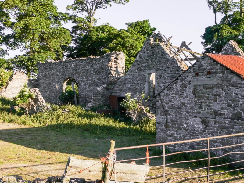
Farmhouse and byre. C17. Dated 1661 for T.P. over door. C19 alterations to
cow-house. Longhouse plan. Coursed squared sandstone rubble with quoins and
ashlar dressings; stone-flagged roof with stone gable copings. 2 storeys, 2 and
3 bays. 2-bay house at left has gabled stone porch; double-ovolo-moulded
surround is broach-stopped, with flat-Tudor-arched head and inscribed lintel,
under cavetto-moulded label mould. Studded boarded door. Wide window at left
under stone lintel; 3-light single-chamfered stone-mullioned window above at
left, and 2-light horizontal sliding sash over door. 2 wide windows inserted in
cow-house at right under flat stone lintels. Left return gable has 3 large
through-stones below left end chimney. Rear has one-storey, 2 bay outshut
under catslide roof. Empty and derelict at time of survey. Interior not
inspected.
Listing NGR: NY9852337512
External links are from the relevant listing authority and, where applicable, Wikidata. Wikidata IDs may be related buildings as well as this specific building. If you want to add or update a link, you will need to do so by editing the Wikidata entry.


Other nearby listed buildings
