Approximate Location Map
Large Map »
Latitude: 52.9265 / 52°55'35"N
Longitude: -1.4814 / 1°28'53"W
OS Eastings: 434958
OS Northings: 336692
OS Grid: SK349366
Mapcode National: GBR PJD.C8
Mapcode Global: WHDGT.6PTV
Plus Code: 9C4WWGG9+JC
Entry Name: Friends Meeting House
Listing Date: 24 February 1977
Grade: II
Source: Historic England
Source ID: 1279318
English Heritage Legacy ID: 403680
ID on this website: 101279318
Location: Derby, Derbyshire, DE1
County: City of Derby
Electoral Ward/Division: Darley
Parish: Non Civil Parish
Built-Up Area: Derby
Traditional County: Derbyshire
Lieutenancy Area (Ceremonial County): Derbyshire
Church of England Parish: Derby St Alkmund and St Werburgh
Church of England Diocese: Derby
Tagged with: Quaker meeting house
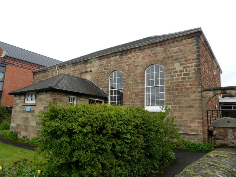
ST HELEN'S STREET
1.
5170
Friends Meeting House
SK 3436 NE 3/238
II
2.
Dated 1808. Small plain stone rectangular building; single-storeyed; added porch
with fabled slate roof and another modern porch at rear on right-hand side; coved
stone eaves; slates. Stone tablet engraved with above date.
Listing NGR: SK3495836692
External links are from the relevant listing authority and, where applicable, Wikidata. Wikidata IDs may be related buildings as well as this specific building. If you want to add or update a link, you will need to do so by editing the Wikidata entry.


Other nearby listed buildings
