Approximate Location Map
Large Map »
Latitude: 51.4483 / 51°26'54"N
Longitude: -2.618 / 2°37'4"W
OS Eastings: 357150
OS Northings: 172331
OS Grid: ST571723
Mapcode National: GBR C2M.XN
Mapcode Global: VH88M.KVTL
Plus Code: 9C3VC9XJ+8R
Entry Name: The Pump House Public House
Listing Date: 18 February 1972
Last Amended: 30 December 1994
Grade: II
Source: Historic England
Source ID: 1279539
English Heritage Legacy ID: 379474
ID on this website: 101279539
Location: Hotwells, Bristol, BS8
County: City of Bristol
Electoral Ward/Division: Hotwells and Harbourside
Parish: Non Civil Parish
Built-Up Area: Bristol
Traditional County: Gloucestershire
Lieutenancy Area (Ceremonial County): Bristol
Church of England Parish: Clifton Holy Trinity with St Andrew the Less and St Peter
Church of England Diocese: Bristol
Tagged with: Pub
BRISTOL
ST5772 CUMBERLAND BASIN, Floating Harbour
901-1/41/1287 (North side)
18/02/72 The Pump House Public House
(Formerly Listed as:
CUMBERLAND BASIN
Hydraulic Engine House)
II
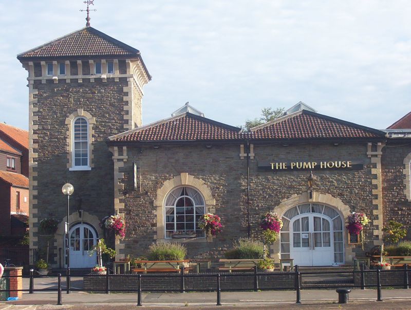
Hydraulic engine house, now public house. c1870. By Thomas
Howard. Squared Pennant rubble with limestone dressings and a
pantile hipped roof. Single storey; 4-window range. Engine
house and left-hand square 2-stage acccumulator tower have
pronounced quoins, jambs and voussoirs. The engine house has a
central block with paired hipped roofs with ridge lights, a
wide elliptical-arched carriage entrance to the right, and
large semicircular-arched window to the left, with paired
eaves brackets at the corners; right-hand section set back has
a small semicircular-arched doorway to the right, with a
narrow window above. The tower has a semicircular-arched
doorway, and narrow window above, and brackets to the
pyramidal roof with a wrought-iron weather vane; in the left
return is a large cross arrow slit. INTERIOR: remodelled and
converted to a public house. Designed by Howard, the Docks
Engineer, to provide hydraulic power to the Cumberland Basin.
(Lord J and Southam J: The Floating Harbour: Bristol: 1983-:
62).
Listing NGR: ST5715072331
External links are from the relevant listing authority and, where applicable, Wikidata. Wikidata IDs may be related buildings as well as this specific building. If you want to add or update a link, you will need to do so by editing the Wikidata entry.


Other nearby listed buildings
