Approximate Location Map
Large Map »
Latitude: 51.5516 / 51°33'5"N
Longitude: -0.1268 / 0°7'36"W
OS Eastings: 529971
OS Northings: 185297
OS Grid: TQ299852
Mapcode National: GBR FP.W60
Mapcode Global: VHGQS.R8BD
Plus Code: 9C3XHV2F+J7
Entry Name: 1 and 2, Hilldrop Road
Listing Date: 29 September 1972
Last Amended: 30 September 1994
Grade: II
Source: Historic England
Source ID: 1279707
English Heritage Legacy ID: 369013
ID on this website: 101279707
Location: Lower Holloway, Islington, London, N7
County: London
District: Islington
Electoral Ward/Division: St George's
Parish: Non Civil Parish
Built-Up Area: Islington
Traditional County: Middlesex
Lieutenancy Area (Ceremonial County): Greater London
Church of England Parish: St Luke West Holloway
Church of England Diocese: London
Tagged with: Building
ISLINGTON
TQ2985SE HILLDROP ROAD
635-1/34/502 (South side)
29/09/72 Nos.1 AND 2
(Formerly Listed as:
CAMDEN ROAD
Baptist Church)
II
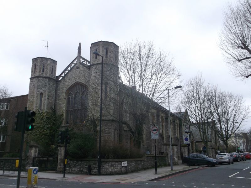
Former Baptist Church and church hall, now hostel. c.1853-4 by
C.G.Searle. Dressed Kentish ragstone with stone dressings,
roof of artificial slate. Nave and chancel under a single roof
with linked two-storey hall at east end, and two octagonal
towers at the west end. North and south elevations of
five-and-a-half bays with pointed-arched windows of three
lights with two transoms, trefoil-headed lights and
rectilinear tracery, the windows flanked by gabled buttresses
with offsets; the westernmost bay has a four-centred-arched
entrance with a pointed-arched window of two lights above.
The west end has a central entrance under a four-centred arch
with engaged columns and foliage capitals, and foliage
mouldings to the archivolt; ogee hoodmould with quatrefoil to
tympanum; four-centred-arched window above with six lights and
one transom, trefoil-headed lights and rectilinear tracery;
two flanking octagonal towers with four-centred arch to ground
floor entrance, trefoiled lancets above, and original roofs
missing; storey band at first floor and gable level; central
gable with openwork parapet and corbelled pinnacle to apex.
The attached wing at the east end has a single-storey gabled
porch with four-centred arch to entrance, two-window range
linking block above with parapet, and two-storey gabled wing,
formerly the church hall: the elevation to Hilldrop Road has
flat-arched three-light windows to two storeys with top lights
and walls of dressed Kentish ragstone, the other sides of
yellow brick. The interior of the church was almost completely
altered for the purposes of a hostel in 1990, but retains an
original staircase with iron rail and balusters in the linking
wing, and two quasi-king-post roof trusses with cusped beams
visible at the west end of the church.
Listing NGR: TQ2997185297
External links are from the relevant listing authority and, where applicable, Wikidata. Wikidata IDs may be related buildings as well as this specific building. If you want to add or update a link, you will need to do so by editing the Wikidata entry.


Other nearby listed buildings
