Approximate Location Map
Large Map »
Latitude: 51.5432 / 51°32'35"N
Longitude: -0.0953 / 0°5'43"W
OS Eastings: 532177
OS Northings: 184417
OS Grid: TQ321844
Mapcode National: GBR Q0.RZ
Mapcode Global: VHGQT.9GGV
Plus Code: 9C3XGWV3+7V
Entry Name: Marquess Tavern Public House
Listing Date: 29 September 1972
Last Amended: 30 September 1994
Grade: II
Source: Historic England
Source ID: 1280203
English Heritage Legacy ID: 368688
Also known as: Marquess Tavern
The Marquess Tavern, Canonbury
ID on this website: 101280203
Location: Canonbury, Islington, London, N1
County: London
District: Islington
Electoral Ward/Division: Canonbury
Parish: Non Civil Parish
Built-Up Area: Islington
Traditional County: Middlesex
Lieutenancy Area (Ceremonial County): Greater London
Church of England Parish: Mildmay Grove St Jude
Church of England Diocese: London
Tagged with: Pub
ISLINGTON
TQ3284SW CANONBURY STREET
635-1/54/197 (North East side)
29/09/72 No.32
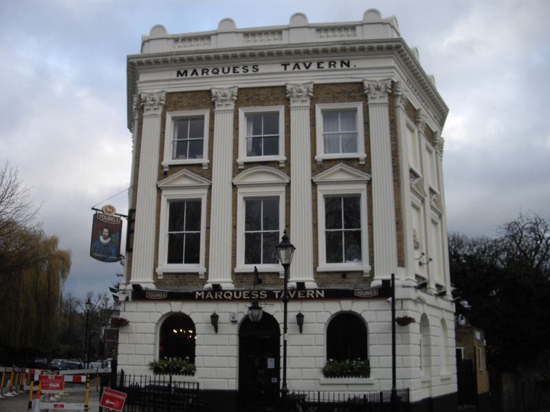
Marquess Tavern PH
(Formerly Listed as:
CANONBURY STREET
No.32
The Marquess of Granby public house)
GV II
Public house. c.1854. Developed by James Wagstaffe. Yellow
brick, stucco, roof obscured by parapets. Three storeys, three
window-range to each street front; the plan exploits the
corner site with the main front to Canonbury Street flat, and
the sides, to Douglas Road and Arran Walk, are each angled in
plan to give two convex facets. Ground floor decorated with
stucco and chamfered rustication; round-arched openings, the
first in Douglas Road blank, the middle one in Canonbury
Street the entrance, and the middle one in Arran Walk blank.
Upper storeys have giant order of Corinthian pilasters.
First-floor windows have moulded stucco architraves and
alternating triangular and segmental pediments; second-floor
windows have moulded stucco architraves; the first and
second-floor windows to Douglas Road, and to the first two
bays in Arran Walk, are blank. Entablature with 'MARQUESS
TAVERN' in sunk lettering to the frieze on each of the three
sides; modillion cornice, parapet with blank balustrade.
Single-storey wing to the rear in Douglas Road with blank
arcading and stucco scored as ashlar to north-west side,
cornice and blocking course.
The interior preserves a horseshoe bar counter and deal
panelling to the dado, both of the second half of the C19 if
not original; also, in the rear wing, Corinthian pilasters and
entablature, moulded ribs to covered roof and lantern (the
lantern now obscured), and mirrors with elaborate architraves
to all four walls: these features all probably of late C19
date.
(Information from Robert Thorne; Historians' file, English
Heritage London Division).
Listing NGR: TQ3217784417
External links are from the relevant listing authority and, where applicable, Wikidata. Wikidata IDs may be related buildings as well as this specific building. If you want to add or update a link, you will need to do so by editing the Wikidata entry.


Other nearby listed buildings
