Approximate Location Map
Large Map »
Latitude: 51.7214 / 51°43'16"N
Longitude: -1.9725 / 1°58'20"W
OS Eastings: 401998
OS Northings: 202518
OS Grid: SP019025
Mapcode National: GBR 3QY.04K
Mapcode Global: VHB2J.RZLR
Plus Code: 9C3WP2CH+H2
Entry Name: 97, Gloucester Street
Listing Date: 24 May 1993
Grade: II
Source: Historic England
Source ID: 1280419
English Heritage Legacy ID: 365323
ID on this website: 101280419
Location: Cirencester, Cotswold, Gloucestershire, GL7
County: Gloucestershire
District: Cotswold
Civil Parish: Cirencester
Built-Up Area: Cirencester
Traditional County: Gloucestershire
Lieutenancy Area (Ceremonial County): Gloucestershire
Church of England Parish: Cirencester St John the Baptist
Church of England Diocese: Gloucester
Tagged with: Building
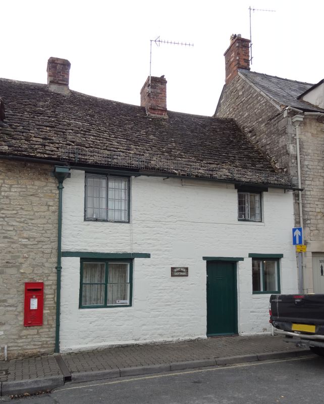
CIRENCESTER
SP0102 GLOUCESTER STREET
578-1/3/187 (South West side)
No.97
GV II
Cottage. Late C18/early C19. Coursed limestone rubble, now
painted; stone slate roof; brick ridge and left-end stacks.
2-storey 2-window range. Two old 2-light leaded casements with
exposed timber lintels to first floor; two C19 two-light
timber casements with exposed timber lintels to ground floor.
Plank door with exposed timber lintel to centre. Shallow
plinth. Rear elevation has further old leaded casements,
possibly C18. INTERIOR very simple, some C20 alteration. Plank
doors with old ironmongery throughout; closed well staircase.
Late C18/early C19 common rafter roof.
Listing NGR: SP0199802518
External links are from the relevant listing authority and, where applicable, Wikidata. Wikidata IDs may be related buildings as well as this specific building. If you want to add or update a link, you will need to do so by editing the Wikidata entry.


Other nearby listed buildings
