Approximate Location Map
Large Map »
Latitude: 51.4538 / 51°27'13"N
Longitude: -2.6132 / 2°36'47"W
OS Eastings: 357489
OS Northings: 172937
OS Grid: ST574729
Mapcode National: GBR C4K.0P
Mapcode Global: VH88M.NQCC
Plus Code: 9C3VF93P+GP
Entry Name: Garden Wall of Richmond House
Listing Date: 4 March 1977
Grade: II
Source: Historic England
Source ID: 1280428
English Heritage Legacy ID: 379250
ID on this website: 101280428
Location: Clifton Wood, Bristol, BS8
County: City of Bristol
Electoral Ward/Division: Clifton
Parish: Non Civil Parish
Built-Up Area: Bristol
Traditional County: Gloucestershire
Lieutenancy Area (Ceremonial County): Bristol
Church of England Parish: Clifton Christ Church with Emmanuel
Church of England Diocese: Bristol
Tagged with: Wall
BRISTOL
ST5772NW CLIFTON HILL, Clifton
901-1/14/792 (East side)
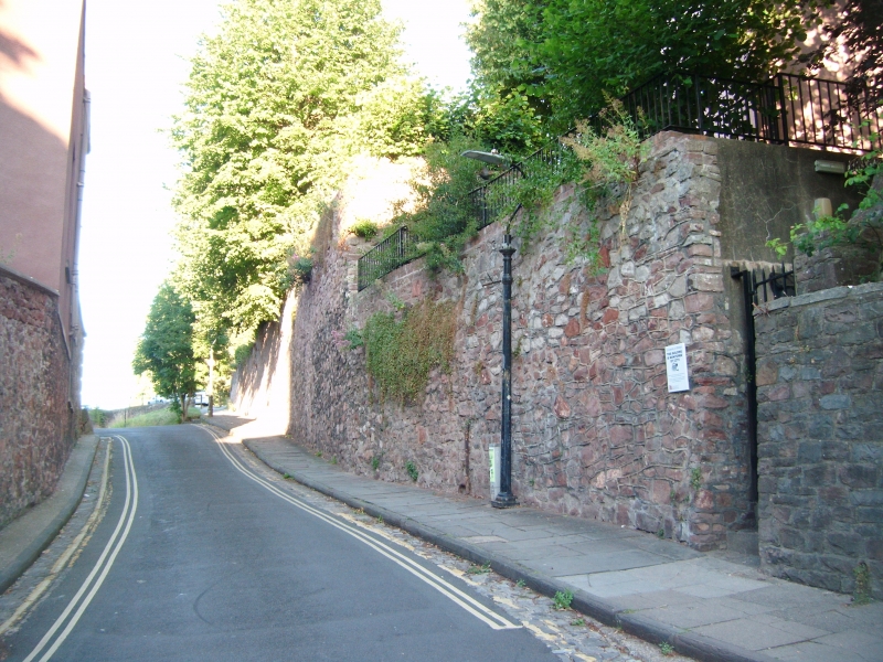
04/03/77 Garden wall of Richmond House
GV II
Garden wall. Late C18. Red sandstone rubble. Retaining wall
above Lower Clifton Hill extends for approx 40m, to the
projecting flagged basement of the house.
Listing NGR: ST5748972937
External links are from the relevant listing authority and, where applicable, Wikidata. Wikidata IDs may be related buildings as well as this specific building. If you want to add or update a link, you will need to do so by editing the Wikidata entry.


Other nearby listed buildings
