Latitude: 50.5197 / 50°31'10"N
Longitude: -2.4511 / 2°27'3"W
OS Eastings: 368117
OS Northings: 68973
OS Grid: SY681689
Mapcode National: GBR PY.LJ4M
Mapcode Global: FRA 57RP.GXK
Plus Code: 9C2VGG9X+VH
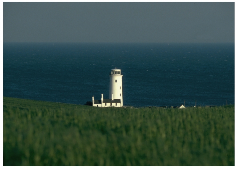
Entry Name: Old Lower Lighthouse, with boundary walls and coastguard house
Listing Date: 21 September 1978
Grade: II
Source: Historic England
Source ID: 1280466
English Heritage Legacy ID: 382000
Also known as: Old Lower Lighthouse
ID on this website: 101280466
Location: Portland Bill, Dorset, DT5
County: Dorset
Civil Parish: Portland
Traditional County: Dorset
Lieutenancy Area (Ceremonial County): Dorset
Church of England Parish: Portland All Saints
Church of England Diocese: Salisbury
Tagged with: Lighthouse
This list entry was subject to a Minor Amendment on 12/12/2019
SY67NE
969-1/1/164
PORTLAND
Portland Bill
PORTLAND BILL ROAD, (south east side)
Old Lower Lighthouse, with boundary walls and coastguard house
21/09/78
II
Lighthouse and house with bird observatory. 1869, modified 1960. Rendered and painted, slate roofs. Slender tapered cylindrical tower, lantern top; domestic block to northeast, linked by flat-roofed one- storey annular extension of c 1960.
Tower has various openings, two-light casements set in deep reveals under cambered projecting lintels and plain cills, crowned by bold cornice carrying cast-iron balustrade with heavy posts and three plain rails to balcony around lantern. Single storey extension has C20 steel casements. Domestic block in two storeys with original three-window unit and a slightly smaller and lower unit added, left. Twelve-pane sashes; central gabled porch, coped verges to bold kneelers, boldly modelled linked triple stack to left gable, and double stack to ridge, right of entrance. Extension also with gable stack to left.
First lighthouse here built 1716, replaced 1789, and again in 1869. Decommissioned 1906 with opening of New Lighthouse (qv); at this time the commemmorative plaque of 1789 removed to the New Lighthouse. Since 1962 used for bird observatory. Used in conjunction with the Old Higher Lighthouse (qv).
Subsidiary Features: enclosed in rubble boundary wall to half-round oversailing copings and a set-back quadrant at entry on the north side, with pair of square piers to pyramidal cappings.
Listing NGR: SY6811768973
External links are from the relevant listing authority and, where applicable, Wikidata. Wikidata IDs may be related buildings as well as this specific building. If you want to add or update a link, you will need to do so by editing the Wikidata entry.


Other nearby listed buildings