Approximate Location Map
Large Map »
Latitude: 52.1909 / 52°11'27"N
Longitude: -1.6992 / 1°41'57"W
OS Eastings: 420659
OS Northings: 254783
OS Grid: SP206547
Mapcode National: GBR 4LT.P6R
Mapcode Global: VHBY0.H6K9
Plus Code: 9C4W58R2+98
Entry Name: Gazebo on Traffic Island Approximately 150 Metres North West of Alveston Manor Hotel
Listing Date: 25 October 1951
Last Amended: 4 April 1994
Grade: II
Source: Historic England
Source ID: 1281387
English Heritage Legacy ID: 366143
ID on this website: 101281387
Location: Stratford-upon-Avon, Stratford-on-Avon, Warwickshire, CV37
County: Warwickshire
District: Stratford-on-Avon
Civil Parish: Stratford-upon-Avon
Built-Up Area: Stratford-upon-Avon
Traditional County: Warwickshire
Lieutenancy Area (Ceremonial County): Warwickshire
Church of England Parish: Alveston St James
Church of England Diocese: Coventry
Tagged with: Gazebo
STRATFORD-UPON-AVON
SP2054 BANBURY ROAD, Bridgetown
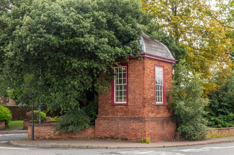
604-1/6/291 Gazebo on traffic island approx. 150
25/10/51 metres north-west of Alveston Manor
Hotel
(Formerly Listed as:
BANBURY ROAD, Bridgetown
Gazebo at Alveston Manor Hotel)
GV II
Gazebo. Early C18. Red brick; fishscale slate ogival roof.
Single storey square structure. Moulded offset to plinth and
nook shafts; top timber cornice, roof with timber finial.
Entrance to south east has rubbed brick flat arch and moulded
frame with 9-pane overlight to half-glazed door with 9 panes.
Windows to other sides have rubbed brick flat arches and
18-pane sashes with moulded frames, one with horns. INTERIOR
has early C18 panelling and corner fireplace; cornice.
Originally in the garden of the Alveston Manor Hotel, but now
situated on a traffic island because of road alterations.
(Buildings of England: Pevsner N: Warwickshire: Harmondsworth:
1966-: 416).
Listing NGR: SP2065954783
External links are from the relevant listing authority and, where applicable, Wikidata. Wikidata IDs may be related buildings as well as this specific building. If you want to add or update a link, you will need to do so by editing the Wikidata entry.


Other nearby listed buildings
