Approximate Location Map
Large Map »
Latitude: 52.1915 / 52°11'29"N
Longitude: -1.7003 / 1°42'0"W
OS Eastings: 420586
OS Northings: 254852
OS Grid: SP205548
Mapcode National: GBR 4LT.GYK
Mapcode Global: VHBY0.H50T
Plus Code: 9C4W57RX+JV
Entry Name: Clopton Bridge and Attached Former Toll House
Listing Date: 25 October 1951
Last Amended: 4 April 1994
Grade: I
Source: Historic England
Source ID: 1204167
English Heritage Legacy ID: 366151
ID on this website: 101204167
Location: Stratford-upon-Avon, Stratford-on-Avon, Warwickshire, CV37
County: Warwickshire
District: Stratford-on-Avon
Civil Parish: Stratford-upon-Avon
Built-Up Area: Stratford-upon-Avon
Traditional County: Warwickshire
Lieutenancy Area (Ceremonial County): Warwickshire
Church of England Parish: Stratford on Avon Holy Trinity
Church of England Diocese: Coventry
Tagged with: Building Road bridge Tollhouse
STRATFORD-UPON-AVON
SP2054 BRIDGE FOOT
604-1/6/6 Clopton Bridge and attached former
25/10/51 toll house
(Formerly Listed as:
BRIDGETOWN
Clopton Bridge)
GV I
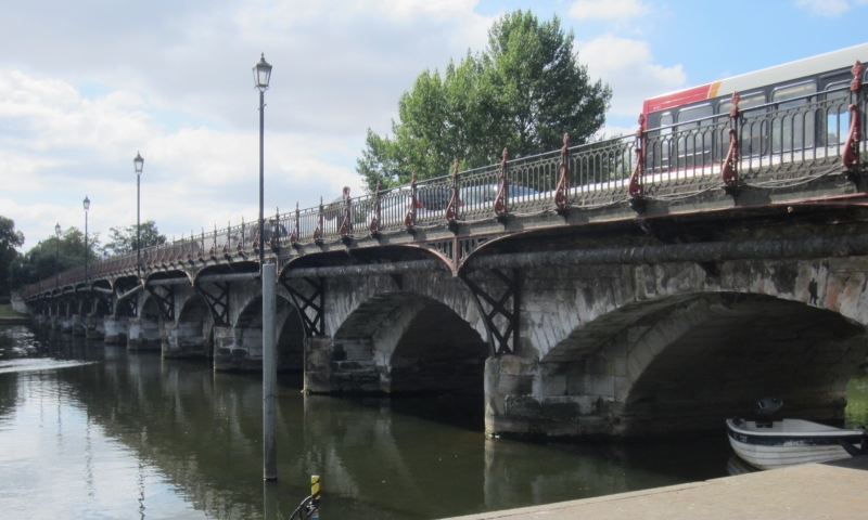
Bridge. c1484 with C16 and C17 repairs; widened and toll house
built 1814; footway added 1827; later parapets. For Sir Hugh
Clopton; footway by J Nicolls, made by the Eagle Foundry,
Birmingham.
Coursed squared stone and ashlar with cast-iron. 14 segmental
pointed arches with platt band and plain parapets over;
widened to north side, which has cutwaters. Cast-iron footway
to north side is cantilevered on lattice work brackets with
enriched spandrels; scrolled supports to posts, which support
panels of rails with semicircular links to head and foot.
10-sided toll house to south of west end has platt band and
crenellated parapet. Entrance, in porch to return, has
4-centred head and door of 4 arched panels, porch is
weather-boarded to return and rear. Windows have sills and
4-centred heads, most are blind, some have small-paned
casements of 2 pointed lights. Bell-form rainwater head.
The bridge was originally attached to a causeway to the west.
An important survival of a medieval bridge forming a
significant landscape feature. A Scheduled Ancient Monument.
(VCH: Styles P: The Borough of Stratford-upon-Avon and the
Parish of Alveston: London: 1946-: 9; Buildings of England:
Pevsner N: Warwickshire: Harmondsworth: 1966-: 416).
Listing NGR: SP2058654852
External links are from the relevant listing authority and, where applicable, Wikidata. Wikidata IDs may be related buildings as well as this specific building. If you want to add or update a link, you will need to do so by editing the Wikidata entry.


Other nearby listed buildings
