Approximate Location Map
Large Map »
Latitude: 50.5583 / 50°33'29"N
Longitude: -2.4328 / 2°25'58"W
OS Eastings: 369438
OS Northings: 73259
OS Grid: SY694732
Mapcode National: GBR PZ.2WMX
Mapcode Global: FRA 57SL.B22
Plus Code: 9C2VHH58+8V
Entry Name: The Citadel, Disused Battery Approximately 150 Metres South East South of South Entrance
Listing Date: 17 May 1993
Grade: II
Source: Historic England
Source ID: 1281857
English Heritage Legacy ID: 381952
ID on this website: 101281857
Location: Fortuneswell, Dorset, DT5
County: Dorset
Civil Parish: Portland
Traditional County: Dorset
Lieutenancy Area (Ceremonial County): Dorset
Church of England Parish: Portland All Saints
Church of England Diocese: Salisbury
Tagged with: Artillery battery
PORTLAND
SY6873 GLACIS, The Verne
969-1/3/170 (West side)
The Citadel, disused battery approx
150m SES of South Entrance
GV II
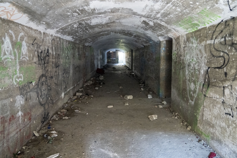
Disused artillery battery. Dated 1892 and 1898. Portland
stone, concrete, brick; tunnels roofed in earth and grass. A
large artillery complex outside the main confines of the
Verne, with 2 single emplacements and a run of 6 linked by
three tunnel runs, and based on series of entrenchments c 4.5
m wide; long N/S run c 120m dying out to north, 3 E/W arms,
and a projecting curved arm of c 55m running out at S/W limit.
Retaining walls to trenches in good ashlar, rough coursed
stone, or brick variously, and rising to c 1.6m on average. At
E end of northernmost arm, and at extreme of SW arm are single
emplacments in concrete and brick, with set of concrete steps
giving to trench; series of 6 emplacements to SE with flat
concrete top, linked by bridge to ramp, with narrow gauge
rails along top and to ramps, also in trench, passing into
tunnel entries N and S. The semicircular emplacements all have
two concentric rows of hexagonal-headed fixing bolts at base.
A cast concrete barrel-vaulted tunnel runs N/S in two
sections; that to N has pedimented arched entries set back in
raked revetments, all rendered, at each end, with square panel
to pediment inscribed VR 1892 over round arch with iron railed
openings. Middle section of tunnel has similar entries but to
flat parapet over segmental arch, down 8 steps to bricked-up
openings, dated VR 1898. Third tunnel runs in an arc W to E,
with 1892 pedimented entries as at north end. Near the S end
of the main N/S trench are two blockhouses, both to heavy
rock-faced stone quoins, and with flat roofs contained with
blocking of large Portland slabs over heavy square cornice,
all former door or window openings blocked. That to N is in
ashlar, and to S is scribed rendering. This was a substantial
emplacement, now outside the main body of The Verne
fortifications and freely accessible to pedestrians.
Listing NGR: SY6943873259
External links are from the relevant listing authority and, where applicable, Wikidata. Wikidata IDs may be related buildings as well as this specific building. If you want to add or update a link, you will need to do so by editing the Wikidata entry.


Other nearby listed buildings
