Approximate Location Map
Large Map »
Latitude: 54.1141 / 54°6'50"N
Longitude: -3.2307 / 3°13'50"W
OS Eastings: 319644
OS Northings: 469388
OS Grid: SD196693
Mapcode National: GBR 5NWV.CZ
Mapcode Global: WH72H.BVTG
Plus Code: 9C6R4Q79+JP
Entry Name: National Westminster Bank
Listing Date: 6 May 1976
Grade: II
Source: Historic England
Source ID: 1283024
English Heritage Legacy ID: 388461
ID on this website: 101283024
Location: Barrow-in-Furness, Westmorland and Furness, Cumbria, LA14
County: Cumbria
District: Barrow-in-Furness
Electoral Ward/Division: Hindpool
Parish: Non Civil Parish
Built-Up Area: Barrow-in-Furness
Traditional County: Lancashire
Lieutenancy Area (Ceremonial County): Cumbria
Church of England Parish: Barrow-in-Furness St Mark
Church of England Diocese: Carlisle
Tagged with: Bank building
BARROW IN FURNESS
SD1969SE DUKE STREET
708-1/12/62 (North East side)
06/05/76 National Westminster Bank
GV II
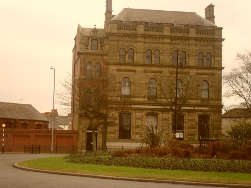
Bank. c1874. For the Lancaster Banking Co (plans register).
Brick and ashlar sandstone on limestone plinth, graduated
slate roof.
3 storeys and attic; 1:4: bays; bay 1 set back and treated
differently, its floor levels lower. Bay 1: rusticated ashlar
ground floor, brickwork above. Ashlar doorcase with panelled
double doors under archivolt with keystone carved spandrels
and modillioned pediment. Central recess above has paired
windows to 1st and 2nd floor: plain sashes with pilaster
mullions impost bands and archivolts. Recess has corbel table
beneath eaves cornice. Pierced parapet with end dies; central
square-headed dormer with cornice on brackets, ball finials
and small pediment raised on panel with carved rose. Mansard
roof with coped gable parapet on left.
Bays 2-5: limestone plinth to ashlar facade. Sill band,
band-rusticated pilasters between ground-floor sashes having
recessed, segmentally-arched surrounds with keystones;
entablature with Vitruvian scroll, C20 fascia sign beneath the
cornice.
1st floor: balustraded aprons and moulded sill band to
round-arched sashes in aedicules with carved spandrels and
dentilled cornices; 1st-floor cornice forms sill to windows
above. 2nd floor: paired windows in recesses between
pilasters; round-arched sashes with pilaster mullions, impost
string course and archivolts. String course and 4 corbel
tables to straight cornice surmounted by balustraded parapet
with dies to each bay division.
Mansard roof with dormers behind the parapet; ashlar end
stacks with offsets and bands.
Formed part of planned scheme around Ramsden Square, the focal
point of Barrow in Furness town centre. Demolished buildings
to right of the bank matched Nos 121 & 123 Duke Street (qv)
situated opposite thus giving a formal entrance to Duke Street
from Ramsden Square.
(Building Plans Register: 1874-: 538 (NO PLANS); Trescatheric
B: Dalton in Furness in Old Picture Postcards: Netherlands:
1982-: PL 3).
Listing NGR: SD1964469388
External links are from the relevant listing authority and, where applicable, Wikidata. Wikidata IDs may be related buildings as well as this specific building. If you want to add or update a link, you will need to do so by editing the Wikidata entry.


Other nearby listed buildings
