Approximate Location Map
Large Map »
Latitude: 53.514 / 53°30'50"N
Longitude: -2.2073 / 2°12'26"W
OS Eastings: 386351
OS Northings: 401940
OS Grid: SD863019
Mapcode National: GBR DS3.QB
Mapcode Global: WHB99.2Y50
Plus Code: 9C5VGQ7V+H3
Entry Name: Church of the Holy Trinity
Listing Date: 20 June 1988
Last Amended: 6 June 1994
Grade: II
Source: Historic England
Source ID: 1283093
English Heritage Legacy ID: 388024
ID on this website: 101283093
Location: Holy Trinity Church, Harpurhey, Manchester, Greater Manchester, M9
County: Manchester
Electoral Ward/Division: Harpurhey
Parish: Non Civil Parish
Built-Up Area: Manchester
Traditional County: Lancashire
Lieutenancy Area (Ceremonial County): Greater Manchester
Church of England Parish: Blackley Holy Trinity
Church of England Diocese: Manchester
Tagged with: Church building
MANCHESTER
SD80SE COBDEN STREET, Harpurhey
698-1/3/706 (East side)
20/06/88 Church of the Holy Trinity
(Formerly Listed as:
COBDEN STREET, Blackley
Church of the Holy Trinity)
II
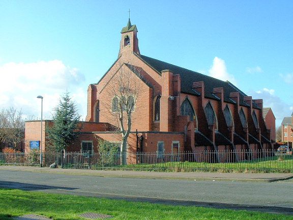
Church. 1908, by Basil Champneys (unfinished). Bright red
brick with some sandstone dressings, pantile roof. Arts and
Crafts Gothic style. Five-bay aisled nave, low chancel
(probably not to original design), narthex. Prominent
slab-like buttresses rising above eaves and finished with
tiled gables, including 2 at west end of south side which have
tusking for intended tower (unbuilt); at west end, a
full-width lean-to narthex piercing 4 buttresses which are
ramped over its roof. Pointed arched west window of 5 lights
with Gothic tracery of stone, and Gothic niches in the
flanking bays; 5-light clerestory windows, square-headed
single lights to the aisles. Bell turret over chancel arch.
Interior: giant pointed-arched arcades, each arch enclosing a
pair of arches with octagonal piers; narrow aisles; panelled
roof with transverse arches; chancel arch blocked to form flat
east end; polygonal font.
Listing NGR: SD8635101940
External links are from the relevant listing authority and, where applicable, Wikidata. Wikidata IDs may be related buildings as well as this specific building. If you want to add or update a link, you will need to do so by editing the Wikidata entry.


Other nearby listed buildings
