Approximate Location Map
Large Map »
Latitude: 53.8104 / 53°48'37"N
Longitude: -1.7765 / 1°46'35"W
OS Eastings: 414814
OS Northings: 434920
OS Grid: SE148349
Mapcode National: GBR JDC.3N
Mapcode Global: WHC98.PH78
Plus Code: 9C5WR66F+4C
Entry Name: Church of St Luke
Listing Date: 9 August 1983
Grade: II
Source: Historic England
Source ID: 1290800
English Heritage Legacy ID: 337286
ID on this website: 101290800
Location: St Luke's Church, Manningham, Bradford, West Yorkshire, BD9
County: Bradford
Electoral Ward/Division: Manningham
Parish: Non Civil Parish
Built-Up Area: Bradford
Traditional County: Yorkshire
Lieutenancy Area (Ceremonial County): West Yorkshire
Church of England Parish: Manningham St Paul and St Jude
Church of England Diocese: Leeds
Tagged with: Church building
1.
5111 VICTOR ROAD
Heaton BD9
Church of St Luke
SE 1434 NE 27/1156
II
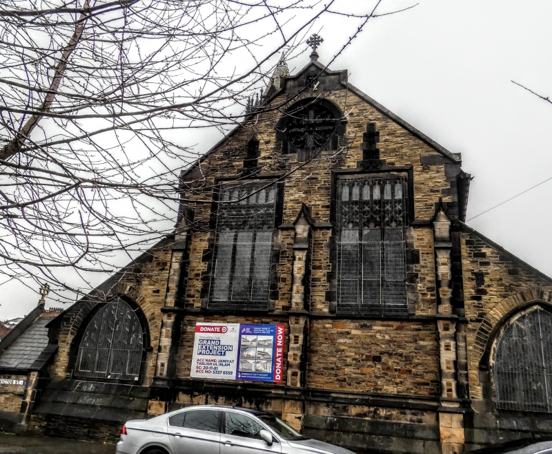
2.
1880-81 by T H and F Healy. Freely handled C14 Gothic and Perpendicular style.
Certain features of the decorative work, more especially the tracery, anticipate
Arts and Crafts design. Unusually for this date the church is built of snecked
ironstone and sandstone with ashlar dressings. Nave, chancel, low aisles with
gabled cross bays and transepts. Principal feature is the virtually detached
campanile tower on the north side. Broad windows with low arches to aisles and
west end with complex ogee tracery and cusping. Flat arched aisle windows with
similar tracery. The tower has a plain sandstone "brick" shaft rising to an
octagonal ashlar belfry with panel tracery to bell openings. Water spouts
project from string at base of crenellated parapet which is crowned by pinnacles
and lucarnes and a short stone spire rises overall. The tower has a crocketed
ogee arched doorway above which is set a canopied niche containing a statue of
St Luke. The tower of St Luke's makes an important contribution to the
Heaton townscape, standing out against the skyline in the hillside.
Listing NGR: SE1481434920
External links are from the relevant listing authority and, where applicable, Wikidata. Wikidata IDs may be related buildings as well as this specific building. If you want to add or update a link, you will need to do so by editing the Wikidata entry.


Other nearby listed buildings
