Approximate Location Map
Large Map »
Latitude: 51.4796 / 51°28'46"N
Longitude: -2.7676 / 2°46'3"W
OS Eastings: 346791
OS Northings: 175905
OS Grid: ST467759
Mapcode National: GBR JH.L2JK
Mapcode Global: VH7C2.Z28K
Plus Code: 9C3VF6HJ+RX
Entry Name: The Farmhouse
Listing Date: 4 August 1981
Grade: II
Source: Historic England
Source ID: 1291033
English Heritage Legacy ID: 394050
ID on this website: 101291033
Location: Portishead, North Somerset, BS20
County: North Somerset
Civil Parish: Portishead
Built-Up Area: Portishead
Traditional County: Somerset
Lieutenancy Area (Ceremonial County): Somerset
Tagged with: Farmhouse
1.
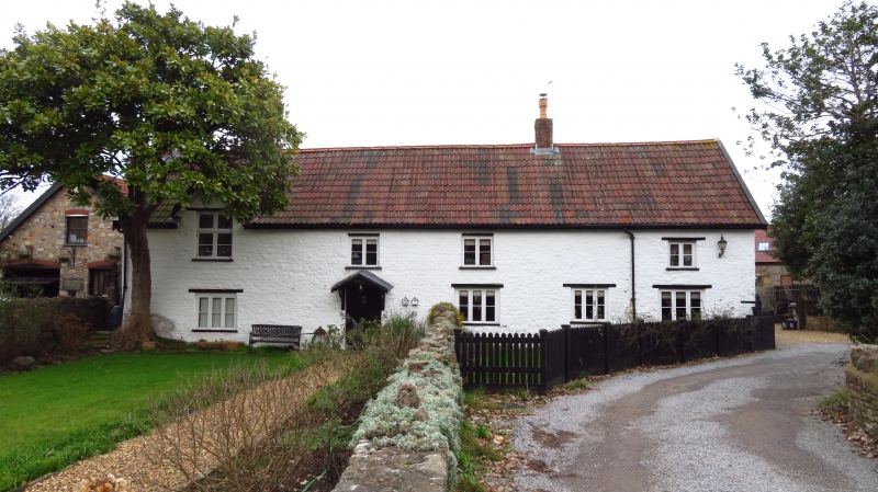
5121 HIGH STREET
(east side)
No 117
(The Farmhouse)
ST 4675 4/13
II
2.
Dated 1700. Traditional low farm house in painted rubble. Double Roman
tiled roof. Two storeys. Five windows; ground floor 3-light, first floor
2-light with wooden mullions. Gabled dormer to north end with datestone.
Listing NGR: ST4679175905
External links are from the relevant listing authority and, where applicable, Wikidata. Wikidata IDs may be related buildings as well as this specific building. If you want to add or update a link, you will need to do so by editing the Wikidata entry.


Other nearby listed buildings
