Approximate Location Map
Large Map »
Latitude: 52.7563 / 52°45'22"N
Longitude: 0.3964 / 0°23'46"E
OS Eastings: 561814
OS Northings: 320328
OS Grid: TF618203
Mapcode National: GBR N3Q.511
Mapcode Global: WHJP1.2Z09
Plus Code: 9F42Q94W+GH
Entry Name: Lattice House
Listing Date: 1 December 1951
Last Amended: 31 August 2018
Grade: II*
Source: Historic England
Source ID: 1291415
English Heritage Legacy ID: 384086
Also known as: The Lattice House, King's Lynn
ID on this website: 101291415
Location: North End, King's Lynn and West Norfolk, Norfolk, PE30
County: Norfolk
District: King's Lynn and West Norfolk
Town: King's Lynn and West Norfolk
Electoral Ward/Division: St Margarets with St Nicholas
Parish: Non Civil Parish
Built-Up Area: King's Lynn
Traditional County: Norfolk
Lieutenancy Area (Ceremonial County): Norfolk
Tagged with: Pub
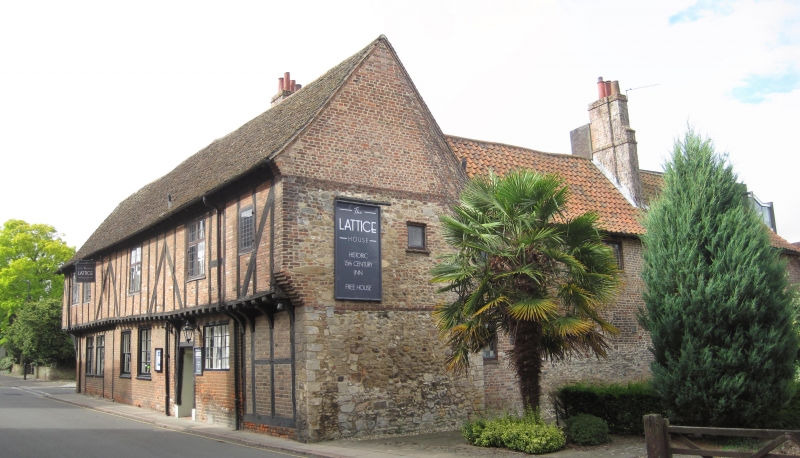
Timber-framed house, built around 1480 as a single range fronting Chapel Street, with two cross-wings added in the late C15 and early C16, and extended to the rear in the C19 and late C20, now a public house.
Timber-framed house, built around 1480 as a single range fronting Chapel Street, with two cross-wings added in the late C15 and early C16, and extended to the rear in the C19 and late C20, now a public house.
MATERIALS: timber-framing; brick infill; plain-tile and pantile roof covering.
PLAN: Late-C15 rectangular-plan building facing east to Chapel Street, with rectangular-plan cross-wings added to the south and north ends of the rear elevation in the late C15 and early C16. A rectangular-plan rear projection was added between the two cross-wings in the C19. Extensions were added to the west end of the south cross-wing in the late C20.
EXTERIOR: the building now known as Lattice House was built as a single two-storey range fronting Chapel Street (formerly Listergate) around 1480, possibly as shops with domestic quarters over. A cross-wing was added to the south end of the rear (west) elevation in the late C15, and another cross-wing added to the north end of the rear elevation in the early C16. A two-storey rear projection was added between the cross-wings in the C19. The whole building was restored between 1981 and 1982, and unified as one commercial premises, with single-storey extensions added to the rear in the late C20. The building has pitched roofs, with plain tiles to the front range and south cross-wing, and pantiles to the north cross-wing and late-C20 rear extensions. The front range has two chimney stacks on its rear (west) slope: that to the north end was inserted in the C18 or C19 and has been rebuilt; and that to the south end was inserted in the C16, probably to heat both the front range and south cross-wing. The walls are generally timber-framed with brick infill. The east and south elevations of the front range are jettied over the ground floor, with a plain jetty bressumer, and a dragon post to the south-east corner on a moulded base. The first floor of the front range has arched and straight braces to the front elevation with C20 brick infill, and brick nogging to the first floor of the south elevation. The ground floor has a doorway to the right of the centre, two two-light timber cross-casement windows to the south end, an eight-over-eight pane timber sash window and 16-light window to the south of the doorway, and a three-light window to the north of the doorway, all exhibiting various degrees of restoration or replacement. The front elevation has four two-light timber cross-casement windows to the first floor, restored but basically C17, with one small C20 casement to the north end. The first floor of the south elevation of the front range has one three-light mullioned casement (restored). The north elevation of the front range has random stone coursing to the ground and first floors, with ashlar quoins to the ground floor and red brick quoins to the first floor, and red brick to the gable. The south cross-wing is two storeys in height, with rendered walls. The south elevation has a door opening to the east end with a blocked window-opening over, and three mullioned windows of 1982 set within C15 frames, that to the east being a six-light dais window with king mullion and transom rising through both floors. The west gable has been rebuilt, and two substantially rebuilt pantiled extensions step down to the west from the gable end. The north cross-wing is a long two-storey range with low courses of rubble stone and two storeys of red brick over, with scattered mixed fenestration, and a rebuilt C16 chimneystack to the north slope.
INTERIOR: Each of the three medieval ranges has a crown-post roof, with differing details and dates, that to the south cross-wing being the only hall open (or reopened) to the roof. The interior is close-studded throughout, with a full complement of chamfered bridging beams and, generally, plain joists, of which mention will only be made when they depart from the usual style. The roof of the front range (facing Chapel Street) comprises square-section crown posts standing on tie beams with arched braces dropping to principal studs, and also arched braces from the posts to the ties. The crown purlin is supported on arched braces, and there are no collar braces. In the north part of the front range, there is a red and black stencil fleur-de-lys wall painting on the south wall of the first-floor room, possibly dating from around 1700. On the ground floor, the central room retains a fireplace with a chamfered bressumer, and the south room retains a timber ceiling structure corresponding with the dragon beam to the south-east corner of the exterior. The plan-form of the former passageway through the building is retained from the front door through a corridor to the rear yard. Throughout the ground floor and in the central room in particular, there is clear evidence of blocked door openings on the north and west walls. The south cross-wing was reopened in the late C20 to reveal the original two-bay open hall, with storeyed rooms to the west jettied into it. The cross-wing has a continuous crown-post roof, with a decorated truss to the two-bay hall, comprising a square-section crown post with chamfered corners (thus appearing octagonal), supported by a moulded tie-beam on chamfered arched braces and corbels. The crown posts have chamfered arched braces to the crown purlin and collars. The western crown truss has straight braces to the tie beam. During restoration work by the District Council in 1982, a piscina was uncovered at the east end of the south wall, comprising a stone trough within an ogee-arched brick recess, plastered to resemble stone, possibly relocated from the Augustinian Friary following dissolution in 1539. The north wall retains a C16 brick fireplace with a timber bressumer. The roof of the north cross-wing has two types of crown posts: one type with polygonal chamfered bases standing on cambered ties, and square-section posts with fillets to each face supporting arched braces to the crown purlin and collars; and the second type of square-section posts with arched braces dropping to flat tie beams. The crown posts have arched braces to the collars and crown purlin. The north wall of the first floor retains a blocked two-light window opening within a chamfered timber surround. The C16 red brick chimneystack of the north-cross wing has a large fireplace and timber bressumer to the west room of the ground floor. A steep and narrow stair in the south-west corner provides access between the ground and first floor.
King’s Lynn, first called Bishop’s Lynn, was founded in 1095 by Bishop Herbert de Losinga, who in the previous year had transferred the see from Thetford to Norwich. There was already an existing settlement which appears to have been based around a salt-water lagoon, or series of inlets, with its centre round the present All Saints Church. Losinga’s town developed to the north of this, between All Saints Church and Saturday Market Place where St Margaret’s Church and Priory were established from Norwich around 1100. Rapid expansion from the C12 onwards required an extension of the town, and Bishop William Turbe laid out a new settlement north of the Purfleet from around 1145, with its market at Tuesday Market Place and the Chapel of St Nicholas as a chapel of ease to St Margaret’s. Both settlements were united under a royal charter in 1204, the united town being named Bishop’s Lynn. Until the early C13, the Great Ouse emptied via the Wellstream at Wisbech, however following floods in the C13, the river was redirected to join the Wash at Bishop’s Lynn. The town became one of England’s busiest ports, serving the Ouse and its tributaries, exporting wool and cloth, and importing wine, timber and luxury goods, being adopted as a member of the original medieval Hanseatic League. This extremely influential trading association linked a group of towns around the Baltic and the North Seas, and played an important role in the prosperity and development of Bishop’s Lynn as a national port, which by the C14, was ranked as the third port of England (after London and Southampton).
Losinga’s town round the Saturday Market was protected from the river immediately to its west by the ‘great bank’, an earthwork which ran along the present line of Nelson Street, St Margaret’s Place and Queen Street. By about 1500 the river had moved approximately 50m west and was consolidated another 45m by the new South Quay in 1855. The period of development of the area between the Millfleet and Purfleet can therefore be identified, as well as building types and plans. The generous-sized plots are reflected in the surviving buildings dating from the C14 to the C17, which surround open courtyards. To the north, on Bishop Turbe’s ‘newe lande’, much the same pattern emerges: originally the west side of Tuesday Market Place was washed by the river, with King Street forming the line of the bank. The west side of King Street was built upon in the C13, with narrow plots, elongating in stages until river movement ceased in the C17. As land became available, warehouses were built straight onto the river front. When Henry VIII dissolved the monasteries in 1536-1537, the town and manor became royal property, and Bishop’s Lynn was renamed King’s Lynn or Lynn Regis.
Lynn’s prosperity as a national port was based entirely on trade, and the merchant class dominated the social and economic life of the town until the C19. When the Fens began to be drained in the mid-C17 and land turned to agricultural use, King’s Lynn grew prosperous from the export of corn: cereal export dominated from the C16, and especially in the C18. Coal and wine continued to be imported for distribution inland, and until the railway age, Lynn was the chief East Anglian port for both. Prosperity continued until continental trade was disturbed by the Napoleonic Wars (1803-1815), followed by a brief revival. The economy and population dwindled following the relatively late arrival of railway services to King’s Lynn in 1847, compounded by the irrevocable decline of coastal trading.
The building now known as Lattice House (Nos 37 to 41 Chapel Street), was built about 1480, and first mentioned in a deed of 1487 as the property of Hugh Crosse, a burgess and merchant. Following Crosse’s death in the same year, the property was granted to the chaplain of the Chapel of St Nicholas as ‘a messuage, land and buildings in Lynn opposite the Augustinian Friars’ conduit in Hobhorslane (later Pillory Lane, and Market Lane since about 1800), extending the length from the highway towards the conduit to the east to land sometime of John Bencle to the west, and in breadth from Hobhorslane to the south to land of the heirs of Robert Braunche to the north’. The street range, which is two-storeys in height and timber framed, extends for about 30 metres along Chapel Street (Listergate until about 1800). The form of a long range parallel to the street was unusual in Bishop’s Lynn, where contemporary buildings mostly ran perpendicular to the street. Two cross-ranges were added to the rear: the south cross-wing appears to have been added in the late C15; and the north cross-wing added in the early C16. A third rear projection was added between the two cross-wings in the C19. Both cross-wings were entered from their side elevation: the south cross-wing was accessed from Market Lane; and the north cross-wing accessed from a passageway through the Chapel Street front. By 1605, the building had come to be subdivided, tenants occupying at least three separate sections of the property, probably as a response to a population increase in Lynn. Chapel wardens’ accounts in 1605 indicate that the central part of the building was occupied by the parish clerk of the Chapel of St Nicholas, and it is certain that the serving parish clerk lived in the building rent-free until 1852. The chapel warden’s accounts for 1617 refer to the south cross-wing as being (recently) divided into tenements. From 1737 there is clear reference in the parish records of a clerk’s shop occupying the north end of the Lattice House street range.
The south part of the building was in use as an inn by 1714, and the ‘Lattice’ name was first adopted at this time, probably recalling alehouse windows which were screened with a trellis or lattice, and generally painted red. The inn was leased to a succession of gentlemen beer brewers, including the Everards, who leased the Lattice from 1764 to 1860. The Lattice was called ‘Ye Olde Lattice Inn’ for many years, until the establishment faced restrictions as a result of the temperance movement, lost its licence and closed in 1919. Vergers of the chapel remained tenanted at Lattice House (the south part of the building) until 1974; the former clerk’s house (central part) of Lattice House was tenanted until 1971; the former clerk’s shop (north part) was occupied until 1970; and the north cross-wing was tenanted as tenements until a closing order was enforced in 1955, and the occupants rehoused by the local authority. After 488 years, the trustees of the Chapel of St Nicholas sold Lattice House to West Norfolk District Council in 1975. An excavation below the hall floor in 1979 revealed evidence of various floor layers, and possible evidence of an earlier building on the site. The building was restored and reopened as a public house in 1982.
Lattice House, built around 1480, with two cross-wings added in the late C15 and early C16, extended in the C19 and late C20, and now a public house, is listed at Grade II* for the following principal reasons:
Architectural interest:
* the building retains a significant proportion of its historic fabric, notably the timber framing and roof structures of the late-C15 front range and late-C15 and early-C16 cross-wings;
* the plan forms of the late-C15 front range and late-C15 and early-C16 cross-wings remain legible.
Historic interest:
* constructed as a merchant’s house in the late C15, with cross-wings added in the late C15 and early C16, Lattice House represents the prosperity of King’s Lynn as a national port in the medieval period;
* it forms a highly significant element in an area of King’s Lynn characterised by its rich architectural and historic legacy.
Group value:
* it has strong group value with many neighbouring listed buildings, notably the Chapel of St Nicholas (listed at Grade I), and 25 Chapel Street, 42 Chapel Street, 1-8 Market Lane, and the north gateway to the former friary precinct, all of which are listed at Grade II.
External links are from the relevant listing authority and, where applicable, Wikidata. Wikidata IDs may be related buildings as well as this specific building. If you want to add or update a link, you will need to do so by editing the Wikidata entry.


Other nearby listed buildings
