Approximate Location Map
Large Map »
Latitude: 54.667 / 54°40'1"N
Longitude: -1.6835 / 1°41'0"W
OS Eastings: 420512
OS Northings: 530256
OS Grid: NZ205302
Mapcode National: GBR JGPG.BT
Mapcode Global: WHC52.3YMM
Plus Code: 9C6WM888+QJ
Entry Name: Newton Cap Bridge
Listing Date: 21 April 1952
Last Amended: 23 January 2023
Grade: I
Source: Historic England
Source ID: 1292118
English Heritage Legacy ID: 385732
Also known as: Skirlaw Bridge
ID on this website: 101292118
Location: Town Head, County Durham, DL14
County: County Durham
Civil Parish: Bishop Auckland
Traditional County: Durham
Lieutenancy Area (Ceremonial County): County Durham
Church of England Parish: Bishop Auckland
Church of England Diocese: Durham
Tagged with: Bridge Road bridge
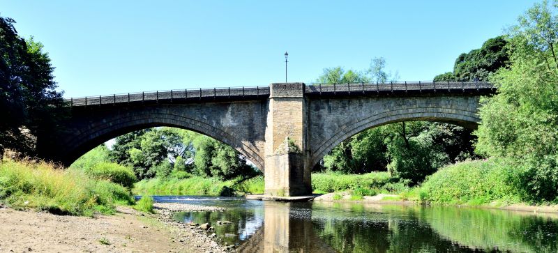
Road bridge, about 1600, with later alterations.
Road bridge, about 1600, with later alterations.
PLAN: oriented almost north-south but crosses the river at a slightly skew angle. Two arches are approached at either end by short causeways, and there is a cantilevered walkway to the east side.
MATERIALS: roughly squared sandstone blocks with larger, more regular blocks to the abutments and central pier, and different coloured stone to the parapets.
DESCRIPTION: the bridge comprises two segmental arches: the southern one with a slightly pointed crown and a span of about 28m; and the northern one with a span of about 30.5m. Both arches have three main arch rings composed of multiple small, well-dressed voussoirs that are generally thin and rectangular. The second and third arch rings are each corbelled out slightly from the ring below, and the northern arch has a more crudely constructed fourth arch ring with less regular voussoirs laid flush with the third. The spandrels are mostly composed of roughly squared blocks laid in irregular horizontal courses; areas of more regular coursing appear to be the result of later patching and rebuilding. The stonework of the abutments and central pier is larger and more regular, of almost ashlar quality.
The bridge's central pier has large pointed cutwaters to each elevation that rise to a narrow stringcourse and terminate in half-hips, while the piers continue up as broad pilaster strips to parapet level where they form trapezoidal pedestrian refuges. The pier has a chamfered step-back just above normal river level. The face of the southern abutment has three chamfered step-backs, and a narrow stringcourse at the level of the springing. A narrow ashlar stringcourse at deck level separates the spandrels from the parapets which, constructed of differently coloured stone to the rest of the bridge, are thought to be replacements, as is the coping.
The western parapet carries a restored inscription recording the leap of an Edward Palfrey from the bridge into the river below in 1744. A modern, pedestrian walkway obscures the eastern parapet and stringcourse, and is partly supported on the abutments and central pedestrian refuge and is also cantilevered out on girders set into the top of the spandrels. Straight joins visible in the parapet walling of the western central pedestrian refuge indicate that a similar walkway once existed against the upstream elevation of the bridge.
The west wall of the southern causeway mostly batters out slightly, while the east wall is vertical to accommodate an L-shaped set of stone steps accessed through a stile in the parapet wall down to the south bank, serving also as buttress. Several stabilising steel tie rods and anchor plates are visible in both causeway walls.
This list entry was subject to a Minor Amendment on 24 January 2023 to amend a typo in the description
There is no evidence to support the presence of a Roman crossing in this location, but there was a medieval bridge by the early C14 when Bishop Kellawe granted indulgences to pay for the construction of a bridge at Newton. ‘Newtonbridge’ is also referenced in an account of repairs to a nearby weir between 1387 and 1388. This bridge would have connected Bishop Auckland (and therefore also the Bishop of Durham’s residence in that town) with routes northwards and westwards upstream along the Wear Valley, where in the medieval period the Bishop had additional landholdings. The present bridge is often claimed as the work of Walter Skirlaw, Bishop of Durham between 1388 and 1405, but stylistically others consider that it could date to anytime between the C14 and C16. A bridge was standing here in 1540 when James Ellison of North Auckland left one mark (13s 4d, or 67 pence) in his will for ‘the amending of Nowton (sic) Bridge’, and in 1565 it was reported as [still] in decay. Saxton's map of 1576 shows the Wear as bridged immediately west of Bishop Auckland. Leland visited County Durham at sometime between 1535 and 1543, and although he does not mention Newton Cap Bridge by name, he is thought to describe the bridge as having a single arch. Recent Historic England research considers the current structure to date from the late C16 or the early C17. The first depiction of the present structure is in a 1733 drawing.
At the turn of the C20 the southern causeway/abutment was rebuilt as part of work to widen the carriageway and to add pedestrian walkways, which were cantilevered out over its elevations. At that time it was suggested that ‘a gateway or gate house’ had once stood at its southern end, and the 1733 drawing supports the idea of some kind of structure in this position. During the 1980s the bridge was stabilised with steel tie rods and anchor plates, and the walkways were both removed in 2002 with only one being replaced. The parapet and its coping stones are thought to be a later rebuilding. The bridge was bypassed in 1995 as part of the Toronto Bypass scheme designed to relieve traffic through the small mining village of that name that stands on the north bank of the Wear. The bridge is now used by local traffic.
Newton Cap Bridge across the River Wear, constructed in about 1600 is listed at Grade I for the following principal reasons:
Architectural interest:
* an early post-medieval bridge, which makes effective use of good quality materials and retains its original fabric, scale and character;
* it comprises two wide segmental arches of slightly different sizes with a central pier and cutwaters, which combine to create an attractive structure of considerable interest;
* it displays good craftsmanship and detailing seen for example in the corbelled arch rings and treatment of the central pier;
* at the time of its construction it is considered to have had the largest span arch in England.
Historic interest:
* it occupies an important and historic bridging point associated with the Bishops of Durham, and demonstrates the undeveloped nature of early road infrastructure.
External links are from the relevant listing authority and, where applicable, Wikidata. Wikidata IDs may be related buildings as well as this specific building. If you want to add or update a link, you will need to do so by editing the Wikidata entry.


Other nearby listed buildings
