Approximate Location Map
Large Map »
Latitude: 50.8261 / 50°49'33"N
Longitude: -0.1617 / 0°9'42"W
OS Eastings: 529571
OS Northings: 104560
OS Grid: TQ295045
Mapcode National: GBR JP3.1Y7
Mapcode Global: FRA B6KX.6V4
Plus Code: 9C2XRRGQ+C8
Entry Name: The Wick Public House
Listing Date: 2 November 1992
Grade: II
Source: Historic England
Source ID: 1292346
English Heritage Legacy ID: 365666
Also known as: Wick Inn
The Wick Inn, Hove
ID on this website: 101292346
Location: Hove, Brighton and Hove, West Sussex, BN3
County: The City of Brighton and Hove
Electoral Ward/Division: Brunswick and Adelaide
Parish: Non Civil Parish
Built-Up Area: Brighton and Hove
Traditional County: Sussex
Lieutenancy Area (Ceremonial County): East Sussex
Church of England Parish: Hove St John the Baptist
Church of England Diocese: Chichester
Tagged with: Pub Thatched pub
HOVE
TQ2904NE WESTERN ROAD
579-1/19/143 (South side)
Nos.62 AND 63
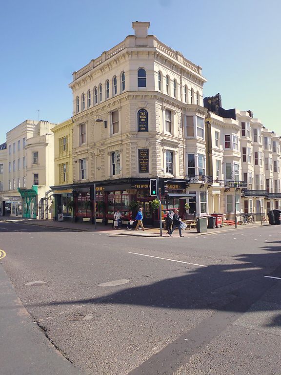
The Wick Public House (63)
GV II
Public house (No.63) and take-away (No.62). Dated 1873, the
rebuilding of an earlier Wick Inn on this site, ground floor
of No.62 altered late C20. Stucco over brick, vermiculated
quoins at junction of facades in angle, roofs concealed behind
parapets.
Plan: public house occupying corner site at junction of
Western Road and Holland Road, take-away abutting to east.
Public house: 4 storeys, single narrow bay at junction
surmounted by stepped parapet, returned as 3 bays left onto
Western Road and 1:1 bays right (Holland Road), sash windows
with one vertical glazing bar, pierced parapet with circle
motif, bracketed cornice, small round arch-head windows,
blocked and painted out, pilasters flanking window openings to
second and first floor with moulded strings, ground floor
pilasters with composite capitals of volutes, roses and
bunches of grapes with original fixed lights, cambered heads
to openings and moulded plinth, etched glass. Western Road
entrance end bay left, half-glazed door with early C20 stained
glass; entrance from Holland Road via single-storey
flat-roofed columnar porch with moulded cornice abutting
3-storey canted bay.
No.62: 3-storey, one bay semi-detached building, tripartite
sash windows with twisted ribbon decoration to mullions of
first and second floor windows, enriched entablature, ground
floor facade rebuilt late C20 but pilasters with capitals
similar to those of No.63 remain beneath the scarlet paint.
The original Wick Inn was a thatched building of some
antiquity, associated with the earliest cricket ground in Hove
which stood on the western side of Holland Road. It is marked
on an 1844 map with the name of the publican of the Wick Inn;
shown as Jem Nye's Ground.
Part of a group with No.82 Western Road (qv) and Palmeira
Mansions, Church Road (qv).
(Middleton J: A History of Hove: 1976-).
Listing NGR: TQ2957104560
External links are from the relevant listing authority and, where applicable, Wikidata. Wikidata IDs may be related buildings as well as this specific building. If you want to add or update a link, you will need to do so by editing the Wikidata entry.


Other nearby listed buildings
