Latitude: 51.5474 / 51°32'50"N
Longitude: -0.1072 / 0°6'25"W
OS Eastings: 531342
OS Northings: 184863
OS Grid: TQ313848
Mapcode National: GBR GK.7MR
Mapcode Global: VHGQT.3C5M
Plus Code: 9C3XGVWV+X4
Entry Name: 14 and 16, Furlong Road
Listing Date: 30 September 1994
Grade: II
Source: Historic England
Source ID: 1292569
English Heritage Legacy ID: 368903
ID on this website: 101292569
Location: Barnsbury, Islington, London, N7
County: London
District: Islington
Electoral Ward/Division: St Mary's
Parish: Non Civil Parish
Built-Up Area: Islington
Traditional County: Middlesex
Lieutenancy Area (Ceremonial County): Greater London
Church of England Parish: St Mary Magdelene and St David Holloway
Church of England Diocese: London
Tagged with: Building
ISLINGTON
TQ3184NW FURLONG ROAD 635-1/45/402 (North side) Nos.14 AND 16
GV II
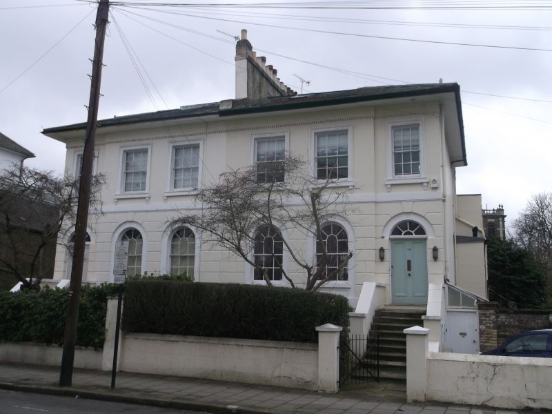
Semi-detached villas. c.1830. Stucco over brick; Welsh and artificial slate roofs. Sidehall entrance with staircase. 2 storeys with basements and attics; 3 windows each. Entrance bay set-back. Rusticated raised ground-floors with sill band beneath round-arched openings. Recessed sash windows with curved and radiating glazing bars in panelled recess. Steps rise to doorway: original twin-panelled doors and radiating fanlight with original glazing bars. 1st floors of plain stucco with storey band beneath hipped roof with projecting eaves and stuccoed centre-wall stacks; dormers.
Listing NGR: TQ3134284862
External links are from the relevant listing authority and, where applicable, Wikidata. Wikidata IDs may be related buildings as well as this specific building. If you want to add or update a link, you will need to do so by editing the Wikidata entry.


Other nearby listed buildings