Approximate Location Map
Large Map »
Latitude: 52.3395 / 52°20'22"N
Longitude: -2.281 / 2°16'51"W
OS Eastings: 380954
OS Northings: 271303
OS Grid: SO809713
Mapcode National: GBR 0C0.650
Mapcode Global: VH920.FG0D
Plus Code: 9C4V8PQ9+QJ
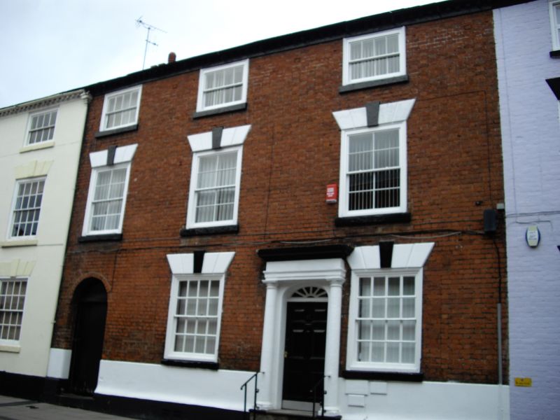
Entry Name: 17, New Street
Listing Date: 5 July 1950
Grade: II
Source: Historic England
Source ID: 1292648
English Heritage Legacy ID: 393372
ID on this website: 101292648
Location: Stourport-on-Severn, Wyre Forest, Worcestershire, DY13
County: Worcestershire
District: Wyre Forest
Civil Parish: Stourport-on-Severn
Built-Up Area: Stourport-on-Severn
Traditional County: Worcestershire
Lieutenancy Area (Ceremonial County): Worcestershire
Church of England Parish: Stourport-on-Severn and Wilden
Church of England Diocese: Worcester
Tagged with: Building
STOURPORT ON SEVERN
SO8071SE NEW STREET
589-1/8/63 (North side)
05/07/50 No.17
GV II
House, now in use as offices. c1800. Brick with Welsh slate
roof. 3-storeyed, 3 principal bays and additional bay
comprising passage way with windows over. Central 6-panelled
door and traceried fanlight in pedimented case with Ionic
columns and flat entablature. 16-pane sash windows with
flat-arched stuccoed heads with voussoirs and keystones. Some
upper windows renewed 8-pane sashes in original openings.
Modillion eaves cornice, gable end stacks.
Listing NGR: SO8095471303
External links are from the relevant listing authority and, where applicable, Wikidata. Wikidata IDs may be related buildings as well as this specific building. If you want to add or update a link, you will need to do so by editing the Wikidata entry.


Other nearby listed buildings
