Latitude: 51.3928 / 51°23'34"N
Longitude: 0.1147 / 0°6'52"E
OS Eastings: 547223
OS Northings: 168097
OS Grid: TQ472680
Mapcode National: GBR QF.3KN
Mapcode Global: VHHP4.X8Z3
Plus Code: 9F3294V7+4V
Entry Name: 91, High Street
Listing Date: 4 August 1983
Grade: II
Source: Historic England
Source ID: 1298993
English Heritage Legacy ID: 358681
ID on this website: 101298993
Location: St Mary Cray, Bromley, London, BR5
County: London
District: Bromley
Electoral Ward/Division: Cray Valley East
Parish: Non Civil Parish
Built-Up Area: Bromley
Traditional County: Kent
Lieutenancy Area (Ceremonial County): Greater London
Church of England Parish: Cray Valley
Church of England Diocese: Rochester
Tagged with: Building
TQ4370 NE
2/24
St Mary Cray
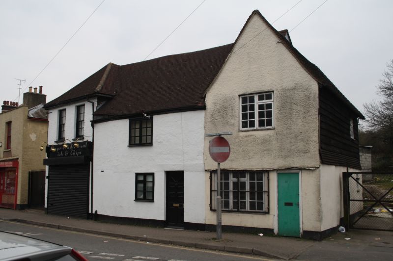
HIGH STREET No. 91
GII
Possibly C16,much altered.Apparently the south cross range of a two-storeyed,timber framed house,the middle range of which survives as No.89.Plastered with weather-boarding to upper storeys at side and rear.Tiled roof.Altered openings with shop to ground storey.
Listing NGR: TQ4372970955
External links are from the relevant listing authority and, where applicable, Wikidata. Wikidata IDs may be related buildings as well as this specific building. If you want to add or update a link, you will need to do so by editing the Wikidata entry.


Other nearby listed buildings