Approximate Location Map
Large Map »
Latitude: 54.3164 / 54°18'58"N
Longitude: -2.2056 / 2°12'20"W
OS Eastings: 386724
OS Northings: 491217
OS Grid: SD867912
Mapcode National: GBR FL1J.9G
Mapcode Global: WHB5F.3R0W
Plus Code: 9C6V8Q8V+GQ
Entry Name: Bridge over Hardraw Beck
Listing Date: 9 July 1986
Grade: II
Source: Historic England
Source ID: 1301072
English Heritage Legacy ID: 323174
ID on this website: 101301072
Location: Hardraw, North Yorkshire, DL8
County: North Yorkshire
District: Richmondshire
Civil Parish: High Abbotside
Traditional County: Yorkshire
Lieutenancy Area (Ceremonial County): North Yorkshire
Tagged with: Bridge
This list entry was subject to a Minor Amendment on 06/03/2018
SD 89 SE
7/149
HIGH ABBOTSIDE
HARDRAW
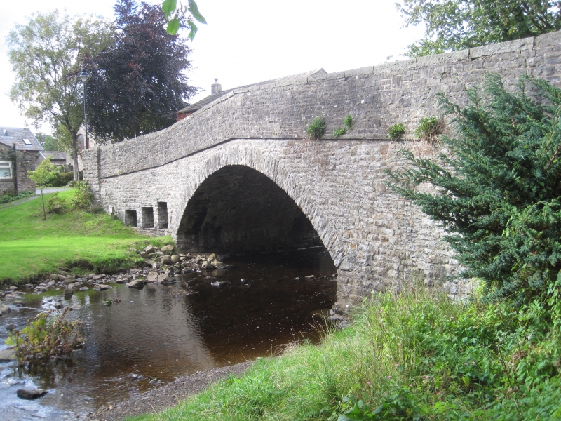
Bridge over Hardraw Beck
(Formerly listed as Bridge over Hardrow Beck, HARDROW)
GV
II
Bridge. c1889. Rubble. Single segmental arch of rubble voussoirs. Band. Slab coping to parapet. In west abutment, three rectangular openings for floodwater. Built after the old bridge was swept away in a great storm in 1889.
Listing NGR: SD8672491217
External links are from the relevant listing authority and, where applicable, Wikidata. Wikidata IDs may be related buildings as well as this specific building. If you want to add or update a link, you will need to do so by editing the Wikidata entry.


Other nearby listed buildings
