Approximate Location Map
Large Map »
Latitude: 52.3869 / 52°23'12"N
Longitude: 0.2086 / 0°12'31"E
OS Eastings: 550403
OS Northings: 278835
OS Grid: TL504788
Mapcode National: GBR M6L.CK7
Mapcode Global: VHHJC.K8NK
Plus Code: 9F4296P5+QC
Entry Name: 66, Main Street
Listing Date: 19 August 1988
Grade: II
Source: Historic England
Source ID: 1302291
English Heritage Legacy ID: 49525
ID on this website: 101302291
Location: Witchford, East Cambridgeshire, CB6
County: Cambridgeshire
District: East Cambridgeshire
Civil Parish: Witchford
Built-Up Area: Witchford
Traditional County: Cambridgeshire
Lieutenancy Area (Ceremonial County): Cambridgeshire
Church of England Parish: Witchford
Church of England Diocese: Ely
Tagged with: Building
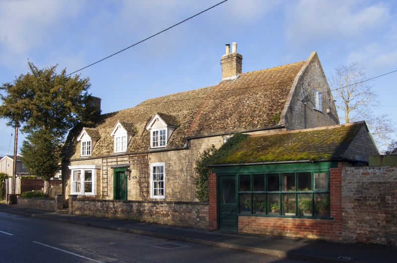
WITCHFORD MAIN STREET
TL 5078 (north side)
20/35 No 66
GV II
House. Late C18 and early C19 extension at east end. Gault brick, English bond
with mansard roof, plain tiled with sawtooth eaves cornice. End stacks to late
C18 cottage, are now internal following early C19 addition at east end. T-plan.
One storey and attic. Three C19 gable dormers with shaped bargeboarding and
horizontal sliding sashes. Early C19 doorway in reeded doorcase with narrow hood.
Panelled reveals. One later canted bay and an original twelve pane hung sash
in segmental arch. At east end, a single bay early C19 service addition. Similar
brick and bond with mansard roof and tumbled gable end. Two storeys. One three-
light first floor casement and a ground floor window in segmental header arch.
Late C18 rear wing late C18 of gault brick with tumbled gable end. Interior:
Two room flank hall. One to the west has an inglenook, and may originally have
been the kitchen. The rear wing has a cellar and pantry, the latter with corner
cupboards. C19 fixed hand basin to side of door. There is another inglenook
in the early C19 addition.
Listing NGR: TL5040378835
External links are from the relevant listing authority and, where applicable, Wikidata. Wikidata IDs may be related buildings as well as this specific building. If you want to add or update a link, you will need to do so by editing the Wikidata entry.


Other nearby listed buildings
