Latitude: 51.2489 / 51°14'56"N
Longitude: -0.7611 / 0°45'39"W
OS Eastings: 486566
OS Northings: 150698
OS Grid: SU865506
Mapcode National: GBR D9S.LDC
Mapcode Global: VHDXW.RVJZ
Plus Code: 9C3X66XQ+HH
Entry Name: Former Masonic Hall
Listing Date: 9 June 1982
Grade: II
Source: Historic England
Source ID: 1302921
English Heritage Legacy ID: 137893
ID on this website: 101302921
Location: Aldershot, Rushmoor, Hampshire, GU11
County: Hampshire
District: Rushmoor
Electoral Ward/Division: Wellington
Parish: Non Civil Parish
Built-Up Area: Aldershot
Traditional County: Hampshire
Lieutenancy Area (Ceremonial County): Hampshire
Church of England Parish: Aldershot Holy Trinity
Church of England Diocese: Guildford
Tagged with: Architectural structure
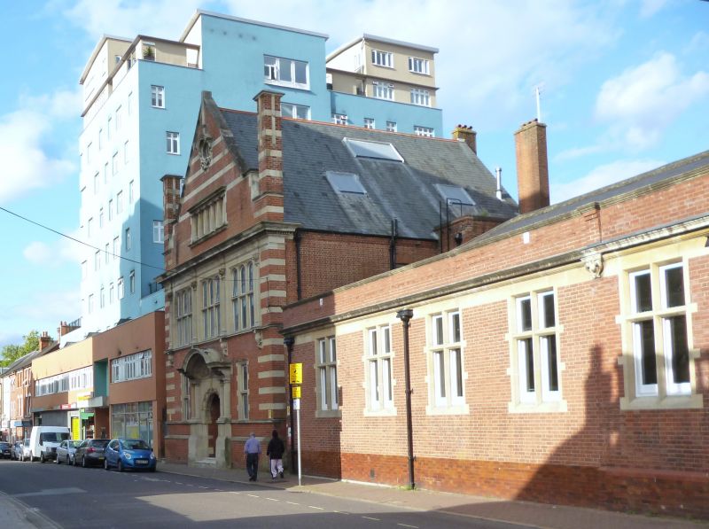
STATION ROAD 1. 5238 (east side) Aldershot Former Masonic Hall SU 8650 5/67 II 2. 1902 by Coggin and Wallis.
Dutch/Jacobean style, being mainly an elaborately ornamental gabled front abutting the street, 2 storeys and attic. Walling in red brick (English bond with stone dressings forming the architectural features. Gable contains flush bands linked to ornamental roundel; at a lower level is a 6-light window with cornice and Tuscan 3/4 columns. On each side a banded stack with moulded link to gable. First floor stage is a full Order supported by 4 Compsite capitals above panelled pilasters, enclosing triple round-headed mullion/transom windows; four deep flush bands on each corner. Ground floor has a stepped plinth and a narrow window on each side of an elaborate porch, with arch within classical arched framework of paired Tuscan columns.
Listing NGR: SU8608751108
External links are from the relevant listing authority and, where applicable, Wikidata. Wikidata IDs may be related buildings as well as this specific building. If you want to add or update a link, you will need to do so by editing the Wikidata entry.


Other nearby listed buildings