Latitude: 53.5654 / 53°33'55"N
Longitude: -2.1258 / 2°7'33"W
OS Eastings: 391762
OS Northings: 407646
OS Grid: SD917076
Mapcode National: GBR FWL6.KN
Mapcode Global: WHB94.9NY2
Plus Code: 9C5VHV8F+4M
Entry Name: Church of St Paul
Listing Date: 6 October 1987
Grade: II
Source: Historic England
Source ID: 1309507
English Heritage Legacy ID: 212452
Also known as: St Paul's Church, Royton
ID on this website: 101309507
Location: Royton, Oldham, Greater Manchester, OL2
County: Oldham
Electoral Ward/Division: Royton North
Parish: Non Civil Parish
Built-Up Area: Royton
Traditional County: Lancashire
Lieutenancy Area (Ceremonial County): Greater Manchester
Church of England Parish: Royton St Paul
Church of England Diocese: Manchester
Tagged with: Church building
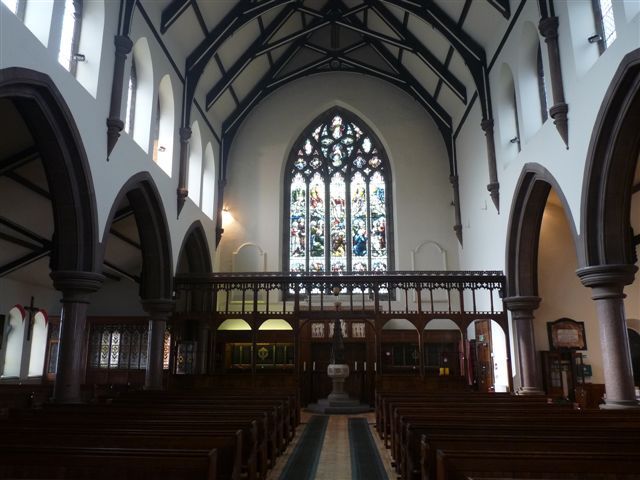
SD 90 NW ROYTON CHURCH STREET 4/48 Church of St. Paul - II Church. 1884-9. By H. Cockburn. Rock-faced stone with slate roof. Nave with clerestory and aisles and north-west steeple. Chancel flanked by side chapel, organ chamber and vestry. Gothic revival. 5-bay nave and aisles with projecting plinth, sill band and corbelled eaves at clerestory level. Each bay has a weathered buttress and 2 cusped lancet window openings to the aisle, and two 2-light clerestory windows. All have hoodmoulds. Twin gables to side chapel and organ chamber. Coped gables with kneelers and finials. 5-light east and west windows have geometrical tracery. Imposing tower with arched entrances to north and west has lancet and round openings on the upper stages, two 2-light transomed belfry openings on each face, an octagonal stair turret in one corner and a broach spire with gabled lucarnes. Interior: double-chamfered nave arcade on circular polished granite columns. Scissor-braced nave roof on columnar corbels. Arch-braced chancel roof. Stone font, timber screens and fittings and stained glass (east window by Hardman). Baluster font dated 1754 and Katherine Pickford wall tablet of 1765.
Listing NGR: SD9176207646
External links are from the relevant listing authority and, where applicable, Wikidata. Wikidata IDs may be related buildings as well as this specific building. If you want to add or update a link, you will need to do so by editing the Wikidata entry.


Other nearby listed buildings