Approximate Location Map
Large Map »
Latitude: 50.1297 / 50°7'47"N
Longitude: -5.6285 / 5°37'42"W
OS Eastings: 140778
OS Northings: 31823
OS Grid: SW407318
Mapcode National: GBR DXHB.LN2
Mapcode Global: VH058.DZ9Y
Plus Code: 9C2P49HC+VJ
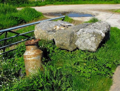
Entry Name: Milkstand at SW407318
Listing Date: 15 December 1988
Grade: II
Source: Historic England
Source ID: 1311600
English Heritage Legacy ID: 69816
ID on this website: 101311600
Location: Cornwall, TR20
County: Cornwall
Civil Parish: Sancreed
Traditional County: Cornwall
Lieutenancy Area (Ceremonial County): Cornwall
Church of England Parish: Sancreed
Church of England Diocese: Truro
Tagged with: Architectural structure
SANCREED
SW 43 SW
2/275 Milk-stand at SW407318
-
GV II
Milk-stand. Circa early C20. Roughly-hewn granite monoliths. Simple construction
with 3 stones forming the working surface.
Listing NGR: SW4077831823
External links are from the relevant listing authority and, where applicable, Wikidata. Wikidata IDs may be related buildings as well as this specific building. If you want to add or update a link, you will need to do so by editing the Wikidata entry.


Other nearby listed buildings
